Home → Fish & Wildlife → Citizen Science Projects → Maine Heron Observation Network → Research Questions
Research Questions
A brief list of questions, projects, and helpful sources for educators and their students
Compiled by Danielle D’Auria, John Brzorad, Ph.D., and the non-profit, 1000 Herons
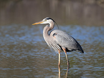
Note: We use the word “heron” throughout. We are currently studying great blue herons (Ardea herodias) in Maine, but this is part of a larger project including great blue herons and great egrets (Ardea alba) from at least six states. The same questions apply to both species, and we encourage the use of the data from birds tagged in other states, too.
The nature of the project with regard to Science
The vast majority of the physical universe is hidden from us. We have limited abilities for detecting sound, light, chemicals or vibration. Nor can we peer easily into time and space. Science is the endeavor that aims at revealing the hidden nature of the tangible (matter, energy) world. All science involves making observations (data collection) and asking questions. The type of science done depends on the type of questions asked and the nature of the system investigated. “How, where, when, do” questions typically lead to descriptive/observational science. How many calories do I burn in a typical day? How much food and time does it take to raise a trout to maturity? Where in an estuary do we find oysters? What is the migratory distance of a great blue heron (Ardea herodias)? Do great blue herons eat turtles?
Once observational questions are answered more probing questions can address causality. This is the realm of hypothesis-driven science that has been fine-tuned using the scientific method. Pound for pound, why do I burn more calories than a lizard? Why does a trout grow better on diet X compared to diet Y? What are the factors (water temperature, light, salinity, depth) that determine the location of oysters in an estuary? Why do herons migrate?
The great blue heron tracking project presents a great opportunity for students to learn and implement the scientific process. By learning a little bit about great blue herons and the tracking project, students can then ask their own questions, do background research, construct hypotheses, and test their hypotheses by using the data generated by the tagged herons. They can do simple analyses of the data to draw their own conclusions and then communicate their results in writing, figures, and tables.
Below, we’ve included some ideas for incorporating the heron tracking project into your learning environment, whether it be a traditional classroom, a homeschool setting, a nature outreach program, a scout group badge, or an independent study. We have started with some focused questions and ideas on how to guide the learning process. We then follow with lists of questions under various topics to help spark some more learning opportunities. Some of our suggestions may be beyond the scope of your work; some can be answered through outdoor exploration; some can be answered using data from Movebank; and others can be answered using credible online sources.
No matter what you choose to investigate or how you go about it, we hope your learning experience is a rewarding one!
Four mini-lessons to consider starting with:
Field Observation Skills
Locate a foraging heron. Where would you expect a heron to feed within a 5-mile radius of your school or home? Consider the habitat types and the land uses within and surrounding those habitats. When do you think a heron would be foraging? Visit a few potential foraging locations at different times of the day to see if you find a heron foraging there. Once you find a foraging heron, observe it for at least a half hour. Practice your field observation skills. Remain quiet and well-hidden so that you do not influence its behavior. Record everything the heron does. Is it feeding, resting, or interacting with other individuals or species? How does it move (quickly, slowly, smoothly, jerkily, walking, running, hopping)? If it was feeding, did it catch a prey item, what was it, how big was it, and how did it eat it (swallow whole, tear into pieces first)? Don't forget to take notes on where you are (include directions, draw a site map, and describe the habitat, water level, plants, etc.), the time of day, and the weather. If you found a foraging heron, visit that same site at the same time of day again to see if it always visits that site at that time of day. If not, vary the timing of your visits to see if you can determine a pattern for when the heron visits the location.
Suggested Resources:
- Google Earth and/or DeLorme Maine Atlas and Gazetteer
- Data sheets (PDF) (with examples of completed data sheets) for recording observations of foraging herons
Discovering Wetland Habitats
Using a wetland map layer (see resources below), identify the different types of wetland habitats the tagged herons use. Learn how the types differ in water depth, plant composition and structure, aquatic fauna, and other variables. Hypothesize what they use each wetland type for. Determine the relative importance of each type to a heron over the course of a year and during the following periods: nesting, spring and fall migration, and wintering. What percentage of the wetlands are classified as Inland Waterfowl and Wading Bird Habitats (IWWH) under Maine's Natural Resources Protection Act? Suggested resources:
- Google Earth
- Map layers for wetlands and IWWH can be found at the Maine Office of GIS Data Catalog: maine.gov/megis/catalog or on Maine DEP's GIS Maps and Other Data Files website: https://www1.maine.gov/dep/gis/datamaps/index.html#nrpa_bird
- Tip: look for the following symbol, which indicates a file that can be brought into Google Earth:

Identifying Patterns
Identify patterns in daily or yearly movements of tagged individuals. Using Google Earth, determine where (location, habitat type, distance from colony or roost) they go and when (time of day, time before/after sunrise/sunset, tide height, time of year)? How are the bird's movement patterns similar? If they are different, what may be the reasons for the differences? Suggested resources:
- Tide Charts: http://usharbors.com/
- Sunrise and sunset times: http://www.timeanddate.com/sun/usa
Calculating Distance, Area, and Perimeter
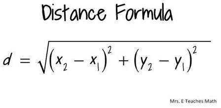
Determine the distance a heron flies from its nesting colony to places it feeds. Using Google Earth, determine the GPS coordinates (in UTMs) of each place it visits, including its nesting colony. Using the distance formula, calculate straight line distances between the locations. If the bird did not fly in a straight line, use the Ruler tool in Google Earth to measure the length of the path. How far does the bird travel before it returns to the colony? How far does it travel in one day? Does it travel in a straight line or does it meander or zigzag before stopping? If it does not travel in a straight line, what could be some reasons for this? What are the sizes of the wetlands it visits – determine the area perimeter of each. Is there a preference for a certain size or shape of wetland it uses for foraging?
Suggested resources:
To measure distance:
If you have the GPS coordinates of two locations in UTMs, you can use the following formula to calculate the distance between the two points (x1, y1) and (x2, y2):
In Google Earth, use the measuring icon on the toolbar (shown below), or go to the Tools menu and click on Ruler.

To calculate the area of a polygon in Google Earth, and you do not have Google Earth Pro, you can use the following website: http://www.earthpoint.us/Shapes.aspx
More questions to spark your inner scientist
Questions about herons
- How does a heron use space differently (or are there differences) over the course of a year (breeding, post-breeding, wintering)?
- How many trips to the nest does it take a heron to raise its young?
- What is the variation in flight distance exhibited by a heron?
- What are UTM coordinates?
- Can we estimate the flight speed of a heron?
- How much area does a heron use at different phases of the year?
- What are the different types of habitats used by herons to feed?
- What sort of food is found in the areas used by herons?
- Where do herons typically construct their nests?
- What are the breeding and wintering ranges of great blue herons.
- How many eggs do great blue herons lay?
- How many young are typically fledged by great blue herons?
- How can a heron be aged?
Questions about heron habitats
- What sorts of places do herons use for food?
- What sorts of places do herons use at night or to raise their young?
- What do herons eat?
- What kinds of places produce the food that herons eat?
- What is an ecosystem?
- What is ecosystem productivity?
- What influences ecosystem productivity?
- Can people influence ecosystem productivity?
- What is a wetland?
- Are there different kinds of wetlands? If so, what are they?
- As sea level rises, what happens to a salt marsh island?
- As sea level rises, what happens to salt marshes on the shore?
Questions about flight
- What is form?
- What is function?
- What do form and function have to do with bird flight?
- Do all birds fly the same way?
- Do all birds feed in the same way?
- Do all birds fly?
- What measurements are useful for describing a bird's wing?
- What else would one have to measure about the bird to make the wing measurements useful?
- Does a bird use only its wings to fly?
- What is lift?
- What is drag?
- What is pitch?
- What is yaw?
- What is roll?
- Explain the X, Y, Z coordinate system.
- What is the force of gravity? What units are used to measure it?
- What is velocity? What units are used to measure it?
- What is acceleration? What units are used to measure it?
- What is energy? What units are used to measure it?
- What is force? What units are used to measure it?
- What is work?
- What, if anything, do energy, force, work and power have to do with birds?
- Where does a bird get its energy?
Questions about heron diets
- What do herons eat?
- What makes up the body of a fish?
- How would you find out how much energy (calories) there is in a fish?
- What are proteins?
- What are carbohydrates?
- What are lipids?
- What are nucleic acids?
- What is water?
- What are nutrients? Why are they important?
- What are micronutrients? Why are they important?
- Do various substances differ in their energy content?
- What is foraging?
- What is feeding?
- What is digestion?
- How are herons different from you in how they digest their food?
- How is bird poop different than human poop? Why?
Questions about technology and tracking birds
- What are latitude and longitude? How are they measured?
- Why do we have seasons?
- Why would seasons be important to an heron?
- How do we launch satellites?
- What does GIS stand for? How is it used?
- What does GPS stand for? How is it used?
- What instruments on a satellite are used to locate a transmitter signal on the Earth?
- How is the distance between a satellite and a transmitter on Earth determined?
- What does VHF stand for? What does UHF stand for?
- What are the units for frequency?
- How does a transmitter work?
- How does a receiver work?
- What is Movebank.org?
- What is a battery?
- Are there different kinds of batteries?
- How do batteries work?
- What is a circuit?
- What is electricity?
- How is electricity generated? Is there more than one way?
- What are photovoltaics?
- How are photovoltaics used to track herons?
Questions about Geography
- Define the study of geography? What does this mean?
- Why is geography important for herons? Why is geography important to people?
- Define north, south, east and west.
- How do we determine direction?
- How does a compass work?
- Where does the sun rise? Where does the sun set?
- How does the sun appear to move through the sky?
- Does this change over the course of a year?
- What is the shape of the earth? How do you know?
- Did people always think this way about the shape of the earth?
- What is a paradigm shift?
- What is climate and what determines it?
- How does climate influence how we grow food?
- How does climate influence ecosytems?
- What is a biome? What is a biogeographic realm?
- How did the Earth form?
- Why are the continents shaped the way that they are?
- What is plate tectonics?
- What are the Eastern, Western, Northern and Southern Hemispheres?
- What is a continent?
- What is an island?
- Does the shape and orientation of a continent influence the climate on that continent?
- What is a country? What is a state or province or region? What is a village, what is a town, what is a city?
- How might the country a heron finds itself in influence its wellbeing?
- What dangers may a heron experience over the course of a year?
- What language is spoken in the country where you find the heron you are tracking?
The nature of the project with regard to the Arts
Here we examine writing, literature, theater, and music.
Questions related to the Arts, English, Environmentalism and History
- Can you imitate the way a heron walks?
- Can you pretend you are a heron? Show the class?
- Write about the year in a heron's life.
- Imagine you are a heron and write about it.
- Tell the story of a heron in a play or dance.
- What sort of call does a heron make? Can you imitate this? Could you use an instrument or instruments to imitate a heron call?
- What value do cranes and storks have in certain Asian cultures? Name these cultures and countries.
- How do different cultures value nature?
- Do animals have spirit? What have various authors written about this subject?
- What is environmentalism? What is Environmental Science?
- Who was Aldo Leopold? Read "A Sand County Almanac" and write a book report.
- Who was John Muir? Describe his life and his writings.
- Who was Theodore Roosevelt? How did he influence the environmental movement in the United States?
- Who is Henry David Thoreau? How did he influence the environmental movement?
- Who is Rachel Carson? How did she influence the environmental movement?
- What influence do environmental writers have on herons? How does their influence work?
Useful tools and links
To measure distance:
1. If you have the GPS coordinates of two locations in UTMs, you can use the following formula to calculate the distance between the two points (x1, y1) and (x2, y2):
2. In Google Earth, use the measuring icon on the toolbar (shown below), or go to the Tools menu and click on Ruler.
To calculate area:
To calculate the area of a polygon in Google Earth, and you do not have Google Earth Pro, you can use the following website: http://www.earthpoint.us/Shapes.aspx
Physics:
Velocity= meters/second, miles/hour Acceleration is change in speed over time; (meters/second)/second; meters/second2 Force = mass X acceleration Watts=Joules/second
More about force, work, energy, and power concepts can be found here: http://hyperphysics.phy-astr.gsu.edu/hbase/work.html