Home → Hunting & Trapping → Hunting → Game Species → Deer → Expanded Archery Season on Deer → Bucksport Area
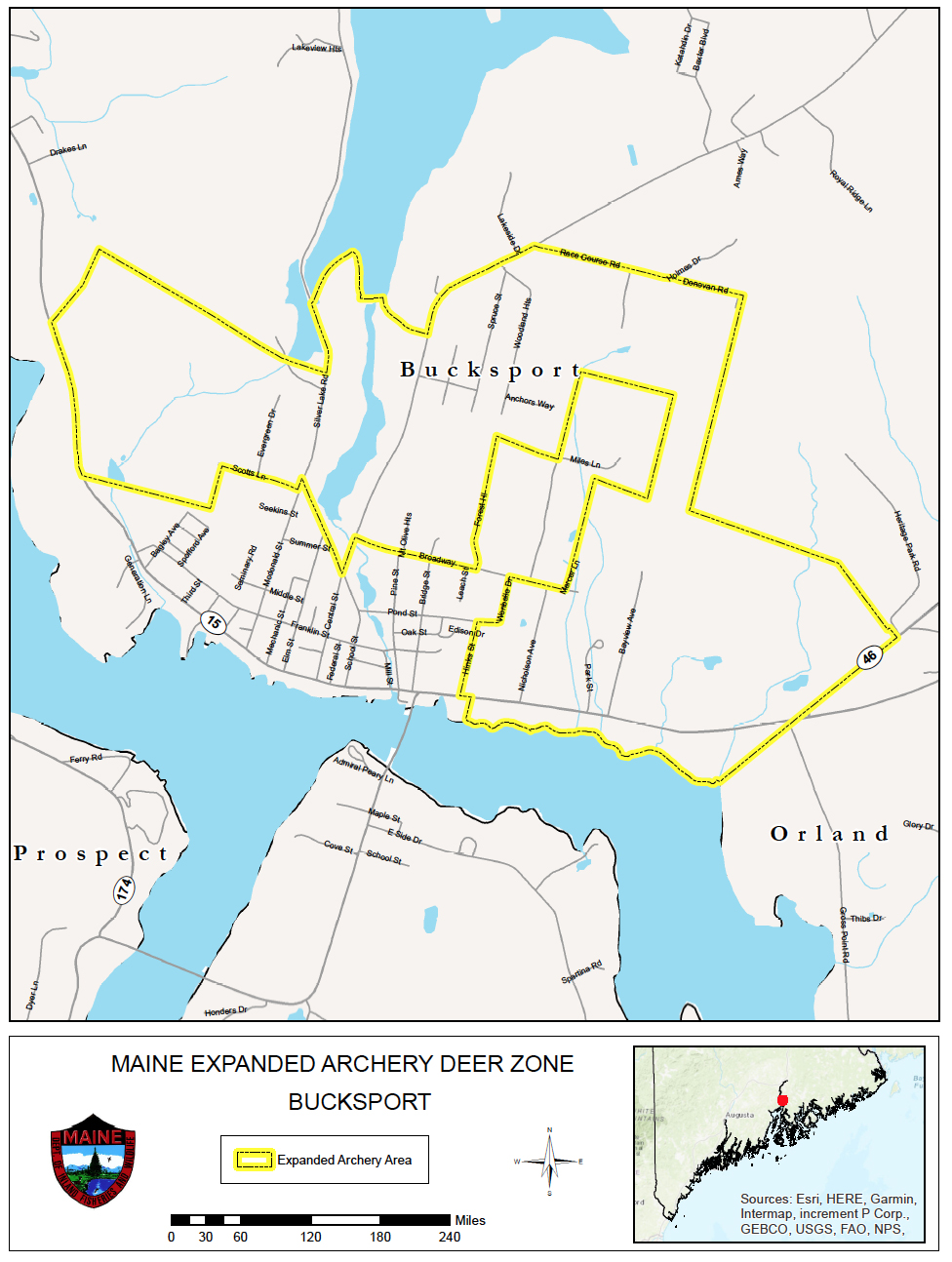
Boundary Description for the Expanded Archery Season on Deer - Bucksport Area
To view PDF documents, you will need the free Adobe Reader. If you need assistance, view our PDF Help page, or email us.
Portions of Bucksport:
Beginning at a point on the eastern side of State Route #15/River Road where the Central Maine Power line right of way intersects State Route #15; then following the right of way northeasterly to a point where it intersects a second CMP right of way extending generally in an east to west direction; then following the second CMP right of way easterly until it intersects Silver Lake Road; then following Silver Lake Road northerly to a point where the road right of way intersects the southern shore of Silver Lake; then following the southern shore of Silver Lake northeasterly and then southeasterly to a point where the shore intersects the access road leading from Central Street to the Silver Lake dam; then following the access road easterly to Central Street; then following Central Street northeasterly to Race Course Road; then following Race Course Road easterly and then easterly beyond its eastern terminus to the northeastern corner of the land of the Penobscot Nursing Home; then following the eastern line of the property of the Penobscot Nursing Home southerly to the CMP right of way; then following the right of way easterly to State Route #46; then following State Route #46 southwesterly to U.S. Route #1; then following U.S. Route #1 approximately 250 meters westerly to the Bucksport/Orland town line; then following the Bucksport/Orland town line southwesterly to the northern shore of the Penobscot River; then following the northern shore of the Penobscot River westerly to a point where the eastern line of the property owned by Hannaford Brothers intersects the northern shore of the Penobscot River; then following the eastern line of the property owned by Hannaford Brothers northerly to U.S. Route #1; then following U.S. Route #1 westerly to Hincks Street; then following Hincks Street northerly to Pond Street; then following Pond Street easterly to Wenbelle Drive; then following Wenbelle Drive northerly to Broadway; then following Broadway easterly to a point where the southeastern corner of property owned by the town and referred to as the Miles Lane Property intersects Broadway; then following the eastern line of the Miles Lane Property northerly to the CMP right of way; then following the CMP right of way easterly to a point where the southeastern corner of land owned by the town and referred to as the New Middle School Property intersects the CMP right of way; then following the eastern line of the New Middle School property northerly to the northeastern corner of the New Middle School Property; then following the northern line of the New Middle School Property westerly to the northwestern corner of the New Middle School Property; then following the western line of the New Middle School Property southerly to the CMP right of way; then following the CMP right of way westerly to a point where Forest Hill Street intersects the CMP right of way; then following Forest Hill Street southerly to Broadway; then following Broadway westerly to Central Street; then following Central Street southerly to School Street; then following School Street northwesterly to MacDonald Street; then following MacDonald Street southerly to Scott’s Lane; then following Scott’s Lane westerly to a point where Scott’s Lane intersects the eastern line of the property owned by Webber Tanks; then following the eastern line of the property owned by Webber Tanks southerly to the southeastern corner of the land owned by Webber Tanks; then following the southern line of the property owned by Webber Tanks westerly to State Route #15/River Road; then following State Route #15 northwesterly to the point of origin at a point on the eastern side of State Route #15/River Road where the Central Maine Power line right of way intersects State Route #15.