Home → Hunting & Trapping → Hunting → Game Species → Deer → Expanded Archery Season on Deer → Bangor Area
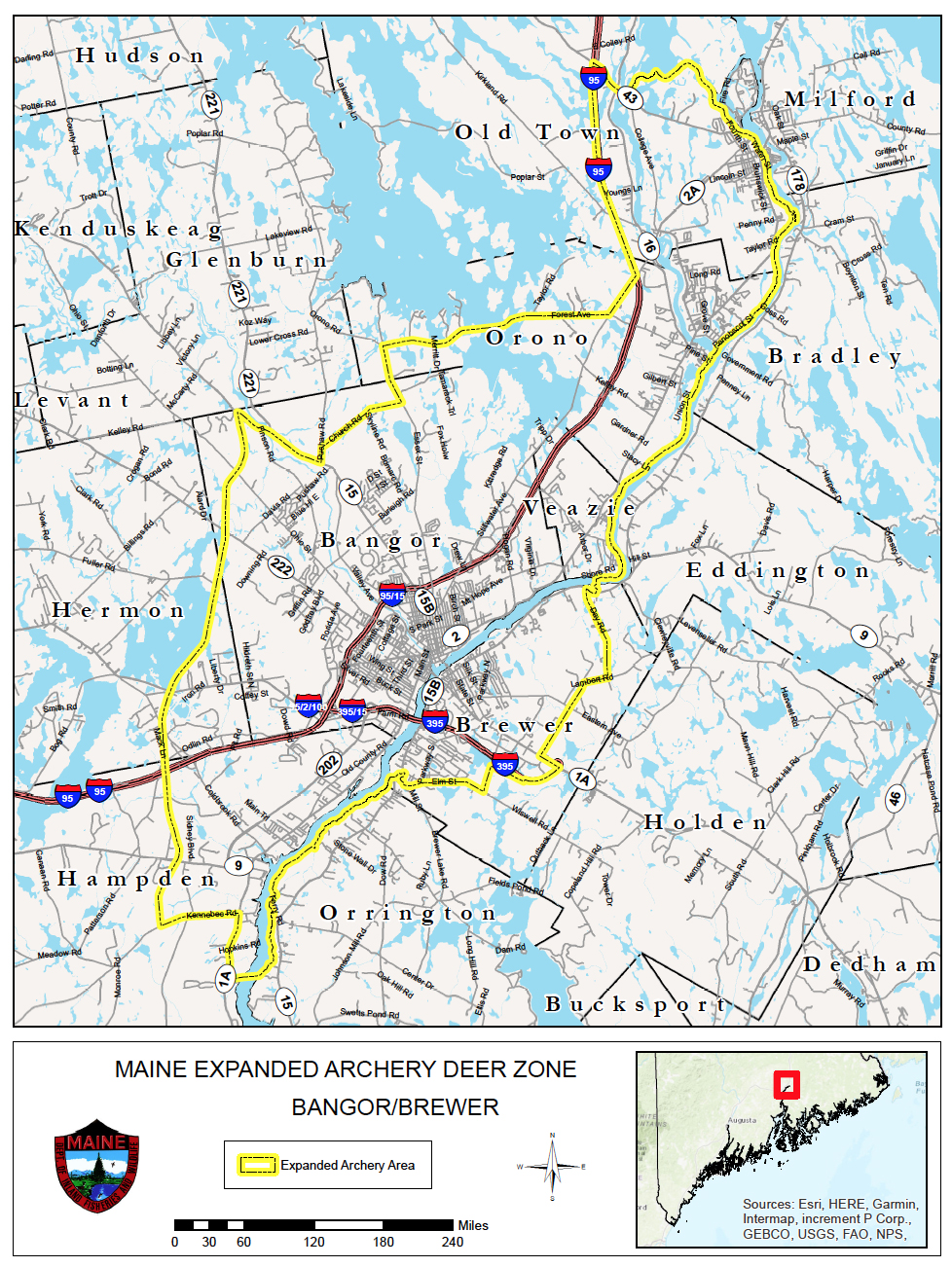
Boundary Description for the Expanded Archery Season on Deer - Bangor Area
To view PDF documents, you will need the free Adobe Reader. If you need assistance, view our PDF Help page, or email us.
Portions of Bangor, Brewer, Hampden, Hermon, Old Town, Orono, and Veazie:
Beginning at a point on the western shore of the Penobscot River directly east of the eastern terminus of Kincaid Road in Hampden; then overland westerly to the eastern terminus of Kincaid Road; then following Kincaid Road westerly to U.S. Route #1A; then following U.S. Route #1A northerly to Kennebec Road; then following Kennebec Road westerly to the intersection with the Bangor and Aroostook Railroad tracks; then following the railroad tracks northerly to the intersection with State Route #15 in Bangor; then following State Route #15 easterly to Pushaw Road; then following Pushaw Road northerly to Church Road; then following Church Road northeasterly to Essex Street; then following Essex Street northerly to Forest Avenue in Orono; then following Forest Avenue easterly to Stillwater Avenue; then following Stillwater Avenue northerly to Interstate Highway #95; then following Interstate Highway #95 northerly to State Route #43 in Old Town; then following State Route #43 easterly to the intersection with the Stillwater River and the shore of Marsh Island; then following the shore of Marsh Island and the Stillwater River northerly and easterly to the Penobscot River; then following the shore of Marsh Island and the Penobscot River southerly to a point at the confluence of the Penobscot River and Eaton Brook in Brewer; then following Eaton Brook southerly to the intersection of State Route #9; then following State Route #9 westerly to Day Road; then following Day Road southerly to Lambert Road; then following Lambert Road westerly to the intersection with the Bangor Hydro transmission line; then following the transmission line southwesterly to Wilson Street; then following Wilson Street southeasterly to the eastbound lane of Interstate Highway #395; then following the eastbound lane of Interstate Highway #395 westerly to the Maine Electric Power Company transmission line; then following the transmission line southwesterly to the intersection with the railroad tracks; then following the railroad tracks westerly to the intersection with Green Point Road; then following Green Point Road southerly to Wiswell Road; then following Wiswell Road westerly to Elm Street; then following Elm Street westerly to the intersection with Sedgeunkedunk Stream; then following Sedgeunkedunk Stream westerly to the eastern shore of the Penobscot River; then following the eastern shore of the Penobscot River southerly to a point on the eastern shore of the Penobscot River directly east of the eastern terminus of Kincaid Road in Hampden; then crossing the Penobscot River westerly to the point of origin at a point on the western shore of the Penobscot River directly east of the eastern terminus of Kincaid Road in Hampden.
Important Note: Land owned by the University of Maine at Orono is not included in the area open to hunting.