This page provides up-to-date information about MaineDOT’s efforts to develop a safe and reliable solution for the Dike Bridge (#2246). As of June 1, 2026, MaineDOT has begun the Environmental Impact Statement (EIS) process for this effort. An EIS establishes the purpose and need for the project, considers input from the public and from state and federal agencies, identifies and evaluates all reasonable alternatives, and identifies a preferred alternative. It will include multiple opportunities for members of the public to provide comments. More information about public meetings and comment periods will be added to this webpage as dates are finalized. Please see the “Project Status and Public Involvement” section below for more details.
MaineDOT will complete environmental review, consultation, and other actions required by applicable Federal environmental laws for federal-aid projects pursuant to - 23 U.S.C. 327 and an MOU executed by FHWA and MaineDOT dated January 30, 2026.
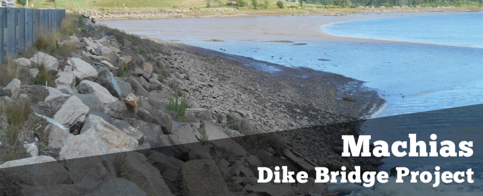
The Machias Dike Bridge carries U.S. Route 1 over the Middle River in Machias and forms an essential part of Maine’s regional highway network. The culverts are constructed of timber and stone masonry and are approximately 130 feet long, 6 feet wide and 5 feet high. Each culvert has top‐hinged flap gate installed on its seaward side. The causeway is constructed of timber cribbing with rubble and earthen fill and is over 1,000 feet long.
The culverts and the flap gates are deteriorated. MaineDOT is studying options to rehabilitate or replace the bridge. Since this project is anticipated to use federal funding for implementation, MaineDOT must follow all applicable federal processes including the National Environmental Policy Act (NEPA).
An update on the current status of the Dike Bridge project is available below.
- Environmental Impact Statement (EIS) Progress
- Project Status/Letter from the MaineDOT Commissioner
June 1, 2026: MaineDOT began the Environmental Impact Statement (EIS) process for the Machias Dike Bridge on June 1, 2026. This is an essential next step in evaluating long-term solutions for this crossing. MaineDOT will follow the process requirements of the National Environmental Policy Act (NEPA) and the Federal Highway Administration (FHWA) implementing regulations to complete the EIS.
MaineDOT and others have completed numerous evaluations and studies on the Dike Bridge that will inform the current effort. However, new consideration of all reasonable alternatives is required as part of the EIS process. No final decisions have been made at this time. More information about the process timeline and public involvement opportunities will be added here as specific dates are confirmed. Current tentative dates are listed below:
- Publication of Notice of Intent (NOI) and outreach to cooperating and participating agencies begins: July 2026
- Public meeting and Public and agency comment period on Purpose & Need and alternatives: September/October 2026
- Public meeting and Public and agency comment period on draft EIS: April/June 2027
MaineDOT anticipates that work on the EIS will be completed in 2027.
- Reference Documents
Below are several background documents that provide information about the work that MaineDOT has completed to date regarding this project. If you have questions regarding the documents or need support with accessibility or other accommodations, please contact Ian Gorecki, MaineDOT Bureau of Planning, via email or at 207-592-0312.
Public and Agency Information Document - Summary (PDF)
Public and Agency Information Document - Appendices, Part 1 (PDF)
Public and Agency Information Document - Appendices, Part 2 (PDF)
Public and Agency Information Document - Appendices, Part 3 (PDF)
- Recent Agency Correspondence
National Marine Fisheries Service Letter - June 14, 2024 (PDF)
- Upper Machias Bay Master Plan
Separately from MaineDOT’s efforts, the Town of Machias and the Sunrise County Economic Council (SCEC) undertook a locally-led process to develop an Upper Machias Bay Master Plan, which was completed in May 2026. This Master Plan included additional opportunities for public involvement and produced locally-developed and locally-supported recommendations for future projects, including the permanent replacement of the Machias Dike Bridge. MaineDOT participated in the process to provide technical information and context regarding the department’s work.
For more information about the Upper Machias Bay Master Plan, including the final report, please visit the UMBMP webpage.
- Previous Meeting Comments and Responses
MaineDOT held a public meeting on June 28th, 2022. A full list of materials from this meeting, including a full meeting transcript, is available below:
- Meeting Transcript (PDF)
- Analyzed Alternatives Matrix (PDF)
- Aerial Inundation Map (PDF)
- Aerial Inundation Map Alternate (PDF)
- Town Seawall Illustration (PDF)
- Machias Dike History (PDF)
- Project Purpose and Need (PDF)
- Potential Bridge Location (PDF)
- NEPA chart (PDF)
MaineDOT, in cooperation with the Town of Machias, hosted an open house for the study on September 14, 2021. The Town of Machias and other also used the open house for input on locally sponsored studies. The purpose of the open house was to solicit feedback on uses of the bridge and causeway and alternatives under consideration, and to educate and discuss options about recent project history and status, alternatives under consideration, and regulatory and decision-making processes. All informational materials from the meeting are available below:
- Machias Public Meeting handout (PDF)
- Alternatives Matrix (PDF)
- Alternatives supporting information (PDF)
- Machias Elevations (PDF)
- SLR Profile - Bridge (PDF)
- SLR Profile - Culvert (PDF)
MaineDOT held a virtual public meeting from March 29-April 30, 2021. Links to the compiled public comments, and MaineDOT’s responses to those comments are included below:
- Right of Way Process