Home → Fishing & Boating → Fishing → Fishing Resources → Maine Fishing Guide → Places to Fish → Region E - Moosehead Region
Region E - Moosehead Region
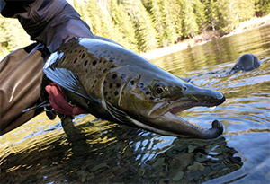
The Moosehead Lake Region is situated in northwestern Maine in the largely undeveloped North Woods. The region contains hundreds of lakes, ponds, and streams that support self-sustaining brook trout populations and many have never been stocked. Anglers enjoy the unique experience of fishing in remote areas for brook trout, landlocked salmon, and lake trout. The centerpiece of the region is Maine's largest lake: Moosehead Lake, which at 40 miles long, offers a big lake fishing experience. If you're looking for moving-water, there are numerous large rivers that provide great fishing for wild brook trout and landlocked salmon, including some year-round opportunities. If you are in search of native brook trout, then the Moosehead Lake Region is the place to be.
— Tim Obrey, Fisheries Resource Supervisor
Special fishing laws may apply to these water bodies. Always check the current Maine Open Water & Ice Fishing Laws first!
Species Key
Primary Fishery Species
 Rainbow Trout (RBT)
 Lake Whitefish (LWF)
 Arctic Charr (CHR)
Status
- Stocked ... (S)
- Wild ... (W)
- Mixture of Stocked & Wild ... (S&W)
Towns
Alder Brook
Appleton
Atkinson
Attean
Bald Mountain
Barnard Twp.
Beattie
Beaver cove
Big Six
Big Squaw
Big W Twp.
Blake Gore
Blanchard
Bowdoin College
Grant East
Bowerbank
Bowdoin College
Grant West
Bradstreet
Brassua
Chesuncook
Comstock
Days Academy
Grant
Dennistown Plt.
Dole Brook
Dover-Foxcroft
Elliotsville
Elm Stream
Forsyth
Gorham Gore
Greenville
Guilford
Hammond
Hobbstown
Holeb
Jackman
Johnson Mountain
Kingsbury
Lily Bay
Little Squaw
Lobster
Long Pond
Lowelltown
Merrill Strip
Misery
Monson
Moose River
Parkman
Perlin Pond
Pittston Academy
Grant
Plymouth
Prentiss
Rainbow
Rockwood Strip
Russell Pond
Saint John
Sandwich
Academy
Sandy Bay
Sangerville
Sapling
Sebec
Seboomook
Shawtown
Shirley
Skinner
Solidertown
Spencer Bay
T1 R11 WELS
T1 R12 WELS
T1 R13 WELS
T2 R12 WELS
T3 R11 WELS
T3 R13 WELS
T4 R12 WELS
T4 R13 WELS
T4 R14 WELS
T4 R11 WELS
T4 R15 WELS
T4 R5 NBKR
T5 R11 WELS
T5 R12 WELS
T5 R14 WELS
T5 R15 WELS
T5 R17 WELS
T5 R18 WELS
T5 R19 WELS
T5 R20 WELS
T5 R7 BKP WKR
T6 R11 WELS
T6 R12 WELS
T6 R13 WELS
T6 R14 WELS
T6 R15 WELS
T6 R17 WELS
T6 R18 WELS
T7 R11 WELS
T7 R12 WELS
T7 R13 WELS
T7 R14 WELS
T7 R15 WELS
T7 R16 WELS
T7 R17 WELS
T7 R17 WELS
T7 R18 WELS
T7 R19 WELS
T7 R9 NWP
T8 R14 WELS
T8 R15 WELS
TA R11 WELS
Thorndike Twp.
Upper Enchanted
Wellington
West Middlesex
Canal Grant
Willimantic
Brook Trout Fishing
Allagash Lake T8 R14 WELS, Piscataquis County
Max Depth: 89 feet, Area: 4,260 acres
Primary Fishery: BKT (W), LKT (W), LWF (W)
Access: Carry in via camp sites or via Allagash Stream.
Notes: No developed launch.
Delorme Atlas: Map 55 section C & D-3
Big Wood Pond Jackman, Somerset County
Max Depth: 72 feet, Area: 2,150 acres
Primary Fishery: BKT (S), LLS (S), SPK (S)
Access: Trailered boat access on Mill Rd.
Notes: Improved launch.
Delorme Atlas: Map 39 section C-4
Canada Falls Lake T2 R4 NBKP, Somerset County
Max Depth: 24 feet, Area: 2,627 acres
Primary Fishery: BKT (W)
Access: Trailered boat access on Canada Falls Rd.
Notes: Improved launch.
Delorme Atlas: Map 48 section D-2
Chamberlain Lake T6 R11 WELS, Piscataquis County
Max Depth: 154 feet, Area: 11,084 acres
Primary Fishery: BKT (W), LKT (W), LWF (W)
Access: Trailered boat access on Telos Rd. Boat up to Chamberlain Lake.
Notes: Improved launch.
Delorme Atlas: Map 56 section E-1 & 2
Long Pond Long Pond Twp, Somerset County
Max Depth: 44 feet, Area: 3,053 acres
Primary Fishery: BKT (S&W), LLS (S&W)
Access: Carry in access off Rte 6.
Notes: No developed launch.
Delorme Atlas: Map 40 section B-1 & 2
Moosehead Lake Greenville, Piscataquis County
Max Depth: 246 feet, Area: 74,890 acres
Primary Fishery: BKT (W), LLS (S&W), LKT (W)
Access: Trailered boat access on Lily Bay Rd (Greenville), Rte 6 (Greenville and Rockwood), Hardwood Valley Rd (Spencer Bay Twp), Seboomook Dam Rd (Seboomook), Ross Farm Rd (Northeast Carry), and in Lily Bay State Park (Greenville).
Notes: Improved launches.
Delorme Atlas: Map 41 and map 49
Rainbow Lake T2 R11 WELS, Piscataquis County
Max Depth: 130 feet, Area: 1,664 acres
Primary Fishery: BKT (W), CHR (W)
Access: Walk in access via Appalachian Trail or float plane.
Notes: No developed launch. No ATV access.
Delorme Atlas: Map 50 section E-3
Rum Pond Greenville, Piscataquis County
Max Depth: 77 feet, Area: 245 acres
Primary Fishery: BKT (W)
Access: Carry in access via gravel road off K I Rd.
Notes: Unimproved launches.
Delorme Atlas: Map 41 section D-4
Salmon Pond T4 R13 WELS, Piscataquis County
Max Depth: 26 feet, Area: 107 acres
Primary Fishery: BKT (S)
Access: Carry in access via gravel road off Salmon Pond Rd.
Notes: Unimproved launch.
Delorme Atlas: Map 49 section C-4
Seboomook Lake Seboomook Twp, Somerset County
Max Depth: 48 feet, Area: 6,448 acres
Primary Fishery: BKT (W)
Access: Trailered boat launches on Seboomook Dam Rd and Seboomook Rd.
Notes: Improved launches.
Delorme Atlas: Map 48 section C-4 & 5
Secret Pond Greenville, Piscataquis County
Max Depth: 33 feet, Area: 14 acres
Primary Fishery: BKT (W)
Access: Walk in access via gravel road off K I Rd.
Delorme Atlas: Map 41 section D-3
Landlocked Salmon Fishing
Attean Lake Attean Twp., Somerset County
Max Depth: 55 feet, Area: 2,745 acres
Primary Fishery: LLS (S), BKT (S)
Access: Trailered boat access on Attean Rd.
Notes: Improved launch.
Delorme Atlas: Map 39 section C-4
Chesuncook Lake & Caribou Lake T3 R12 WELS, Piscataquis County
Max Depth: 150 feet, Area: 26,200 acres
Primary Fishery: LLS (W), BKT (W)
Access: Trailered boat access on Chesuncook Lake Rd (Chesuncook Lake) and Guy Allen Rd (Umbazooksus Stream). Carry in access on Golden Rd (Caribou Lake).
Notes: Improved launches on Chesuncook Lake Rd and Guy Allen Rd and unimproved launch on Golden Rd.
Delorme Atlas: Map 49 and map 50
First Roach Pond Frenchtown, Piscataquis County
Max Depth: 123 feet, Area: 3,270 acres
Primary Fishery: LLS (S&W), LKT (W), BKT (S&W)
Access: Trailered boat access on Lily Bay Rd. Carry in access on Frenchtown Rd.
Notes: Improved launch on Lily Bay Rd and unimproved launch on Frenchtown Rd.
Delorme Atlas: Map 41 section B-5
Harrington Lake T3 R11 WELS, Piscataquis County
Max Depth: 134 feet, Area: 1,332 acres
Primary Fishery: LLS (W), LKT (W), BKT (W)
Access: Trailered boat access on Telos Rd.
Notes: Improved launch.
Delorme Atlas: Map 50 section C-2 & 3
Indian Pond Sapling Twp, Somerset County
Max Depth: 118 feet, Area: 3,746 acres
Primary Fishery: LLS (S&W), BKT (W), LKT (W)
Access: Trailered boat access on Indian Pond Rd and Burnham Pond Rd. Carry in access on VIP Rd.
Notes: Improved launches on Indian Pond Rd and Burnham Rd and unimproved launch on VIP Rd.
Delorme Atlas: Map 40 section C-5
Kingsbury Pond Kingsbury Plt, Piscataquis County
Max Depth: 62 feet, Area: 390 acres
Primary Fishery: LLS (S&W), SPK (S), BKT (S)
Access: Trailered boat access on Rte 16.
Notes: Improved launch.
Delorme Atlas: Map 31 section C-1 & 2
Lobster Lake Lobster Twp Piscataquis County
Max Depth: 106 feet, Area: 3,475 acres
Primary Fishery: LLS (W), LKT (W), BKT (W)
Access: Trailered boat access on Lobster Trip Rd, boat up stream to lake.
Notes: Improved launch.
Delorme Atlas: Map 49 section D-3
Lower Wilson Pond Greenville, Piscataquis County
Max Depth: 106 feet, Area: 1,380 acres
Primary Fishery: LLS (S&W), LKT (W), BKT (W)
Access: Trailered boat launches on North
Shore Rd and Wilson Pond Rd.
Notes: Improved launches.
Delorme Atlas: Map 55 section C & D-3
Moosehead Lake Greenville, Piscataquis County
Max Depth: 246 feet, Area: 74,890 acres
Primary Fishery: BKT (W), LLS (S&W), LKT (W)
Access: Trailered boat access on Lily Bay Road (Greevnille), Rte 6 (Greenville and Rockwood), Hardwood Valley Rd (Spencer Bay Twp), Seboomook Dam Rd (Seboomook), Ross Farm Rd (Northeast Carry), and in Lily Bay State Park (Greenville).
Notes: Improved launches.
Delorme Atlas: Map 41 and map 49
Sebec Lake Dover-Foxcroft, Piscataquis County
Max Depth: 155 feet, Area: 6,803 acres
Primary Fishery: LLS (W), LKT (S)
Access: Trailered boat access on Sebec Village Rd, Route 150 near Earley's Landing Falls and Greely's Landing Rd.
Notes: Improved launches.
Delorme Atlas: Map 31 section A-5 and Map 32 section A-1 & 2
Splake Fishing
Ragged Lake T2 R13 WELS, Piscataquis County
Max Depth: 54 feet, Area: 2,712 acres
Primary Fishery: BKT (W), SPK (S), LLS (W)
Access: Trailered boat access on Sias Hill Rd.
Notes: Improved launch.
Delorme Atlas: Map 49 section D & E-5
Brown/Rainbow Trout Fishing
Center Pond Sangerville, Piscataquis County
Max Depth: 19 feet, Area: 403 acres
Primary Fishery: BNT (S), BKT (S)
Access: Trailered boat access off Silver Mills Rd.
Notes: Improved launch.
Delorme Atlas: Map 32 section C-1
Togue (Lake Trout) Fishing
Allagash Lake T8 R14 WELS, Piscataquis County
Max Depth: 89 feet, Area: 4,260 acres
Primary Fishery: BKT (W), LKT (W), LWF (W)
Access: Carry in via camp sites or via
Allagash Stream.
Notes: No developed launch.
Delorme Atlas: Map 55 section C & D-3
Chamberlain Lake T6 R11 WELS, Piscataquis County
Max Depth: 154 feet, Area: 11,084 acres
Primary Fishery: BKT (W), LKT (W), LWF (W)
Access: Trailered boat access on Telos Rd. Boat up to Chamberlain Lake.
Notes: Improved launch.
Delorme Atlas: Map 56 section E-1 & 2
First Roach Pond Frenchtown, Piscataquis County
Max Depth: 123 feet, Area: 3,270 acres
Primary Fishery: LLS (S&W), LKT (W), BKT (S&W)
Access: Trailered boat access on Lily Bay Rd.
Carry in access on Frenchtown Rd.
Notes: Improved launch on Lily Bay Rd and unimproved launch on Frenchtown Rd.
Delorme Atlas: Map 41 section B-5
Harrington Lake T3 R11 WELS, Piscataquis County
Max Depth: 134 feet, Area: 1,332 acres
Primary Fishery: LLS (W), LKT (W), BKT (W)
Access: Trailered boat access on Telos Rd.
Notes: Improved launch.
Delorme Atlas: Map 50 section C-2 & 3
Lobster Lake Lobster Twp Piscataquis County
Max Depth: 106 feet, Area: 3,475 acres
Primary Fishery: LLS (W), LKT (W), BKT (W)
Access: Trailered boat access on Lobster Trip Rd, boat up stream to lake.
Notes: Improved launch.
Delorme Atlas: Map 49 section D-3
Lower Wilson Pond Greenville, Piscataquis County
Max Depth: 106 feet, Area: 1,380 acres
Primary Fishery: LLS (S&W), LKT (W), BKT (W)
Access: Trailered boat launches on North Shore Rd and Wilson Pond Rd.
Notes: Improved launches.
Delorme Atlas: Map 55 section C & D-3
Moosehead Lake Greenville, Piscataquis County
Max Depth: 246 feet, Area: 74,890 acres
Primary Fishery: BKT (W), LLS (S&W), LKT (W)
Access: Trailered boat access on Lily Bay Rd (Greevnille), Rte 6 (Greenville and Rockwood), Hardwood Valley Rd (Spencer Bay Twp), Seboomook Dam Rd (Seboomook), Ross Farm Rd (Northeast Carry), and in Lily Bay State Park (Greenville).
Notes: Improved launches.
Delorme Atlas: Map 41 and map 49
Nahmakanta Lake T1 R11 WELS, Piscataquis County
Max Depth: 110 feet, Area: 1,024 acres
Primary Fishery: LKT (W), BKT (W), LLS (W)
Access: Carry in access on AT trail off Nahmakanta Stream Rd.
Notes: Unimproved launch.
Delorme Atlas: Map 50 section E-3
Sebec Lake Dover-Foxcroft, Piscataquis County
Max Depth: 155 feet, Area: 6,803 acres
Primary Fishery: LLS (W), LKT (S)
Access: Trailered boat access on Sebec Village Rd and Greely's Landing Rd.
Notes: Improved launches.
Delorme Atlas: Map 32 section A-1 & 2
Rivers / Streams / Brooks
Caucomogmoc Stream T6 R14 WELS, Piscataquis County
Primary Fishery: LLS (W), BKT (W)
Access: Walk in access.
Delorme Atlas: Map 55 section E-3
East Outlet, Moosehead Lake Sapling Twp, Piscataquis County
Primary Fishery: LLS (S&W), BKT (S&W)
Access: Walk in access.
Delorme Atlas: Map 41 section C-1
Moose River T1 R1 NBKP, Somerset County (Brassua Lake to Moosehead Lake)
Primary Fishery: LLS (S&W), BKT (W), LKT (W)
Access: Walk in access.
Delorme Atlas: Map 40 section A & B-5
Penobscot River, North Branch Comstock Twp, Somerset County
Primary Fishery: BKT (W)
Access: Walk in access.
Delorme Atlas: Map 48 section C-2
Penobscot River, South Branch Hammond Twp, Somerset County
Primary Fishery: LLS (W), BKT (W)
Access: Walk in access.
Delorme Atlas: Map 48 section D-1
Penobscot River, West Branch T4 R14 WELS, Piscataquis County
Primary Fishery: LLS (W), BKT (W)
Access: Walk in access.
Delorme Atlas: Map 49 section B-4
Piscataquis River Blanchard Twp, Piscataquis County
Primary Fishery: BKT (S)
Access: Walk in access.
Delorme Atlas: Map 31 section A & B-3
Roach River Spencer Bay Twp, Piscataquis County
Primary Fishery: LLS (W), BKT (W)
Access: Walk in access.
Delorme Atlas: Map 41 section A-3 & 4
Sebec River Sebec Twp, Piscataquis County
Primary Fishery: LLS (W), BKT (S)
Access: Walk in access.
Delorme Atlas: Map 32 section A-4
Upper Moose River Jackman, Somerset County (north of Jackman)
Primary Fishery: BKT (W)
Access: Walk in access.
Delorme Atlas: Map 39 section B-4