Home → Fishing & Boating → Fishing → Fishing Resources → Maine Fishing Guide → Places to Fish → Region C - Grand Lake Region
Region C - Grand Lake Region
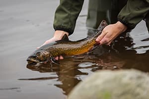
Downeast Maine is home to The Grand Lake Region, which has an exciting mixture of both coldwater and warmwater fishing opportunities. From its scenic coastal plain to its undeveloped, tranquil interior, anglers visiting eastern Maine will have no trouble finding the fish species that suits them. From vibrantly colored brook trout and iconic landlocked salmon to hard-fighting smallmouth bass and the eager biting schools of white perch, it's hard to beat the Grand Lake Region for fishing diversity and a remarkable angling experience.
— Greg Burr, Fisheries Resource Supervisor
Special fishing laws may apply to these water bodies. Always check the current Maine Open Water & Ice Fishing Laws first!
Species Key
Primary Fishery Species
 Rainbow Trout (RBT)
 Smallmouth Bass (SMB)
 Largemouth Bass (LMB)
 Lake Whitefish (LWF)
 Arctic Charr (CHR)
Status
- Stocked ... (S)
- Wild ... (W)
- Mixture of Stocked & Wild ... (S&W)
Towns
Alexander
Amherst
Aurora
Baileyville
Bar harbor
Baring
Beals Island
Beddington
Blue Hill
Brewer
Brooklin
Brooksville
Bucksport
Calais
Castine
Centerville
Charlotte
Cherryfield
Clifton
Codyville
Columbia
Columbia Falls
Cooper
Crawfod
Cutler
Deblois
Dedham
Deer Isle
Dennysville
Dyer
East Machias
Eastbrook
Eastport
Eddington
Edmunds
Ellsworth
Fowler
Franklin
Gouldsboro
Grand Lake Stream
Great Pond
Hancock
Harrington
Holden
Indian
Jonesboro
Jonesport
Lambert Lake
Lamoine
Lubec
Machias
Machiasport
Mariaville
Marion
Marshfield
Meddybemps
Milbridge
Mount Desert
Northfield
Orland
Orrington
Osborn
Otis
Pembroke
Penobscot
Perry
Princeton
Robinnston
Roque Bluffs
Sedgwick
Sorrento
Southwest harbor
Steuben
Stonington
Sullivan
Surry
T10 SD
T16 MD
T18 ED BPP
T18 MD BPP
T19 ED BPP
T19 MD BPP
T22 MD
T24 MD BPP
T25 MD BPP
T26 ED BPP
T27 MD BPP
T30 MD BPP
T31 MD BPP
T34 MD
T35 MD
T36 MD BPP
T37 MD BPP
T42 MD BPP
T43 MD BPP
T5 ND BPP
T6 ND BPP
T6 R1 NBPP
T7 SD
T8 SD
T9 SD
Talmadge
Tremont
Trenton
Trescott
Vanceboro
Verona
Waite
Waltham
Wesley
Whiting
Whitneyville
Winter Harbor
Brook Trout Fishing
Echo Lake Mount Desert, Hancock County
Max Depth: 66 feet, Area: 237 acres
Primary Fishery: BKT (S&W), LLS (S)
Access: Trailered boat access off Rte 102.
Notes: Improved launch.
Delorme Atlas: Map 16 section C-2
Long Pond Great Pond Plt., Hancock County
Max Depth: 36 feet, Area: 271 acres
Primary Fishery: BKT (S&W)
Access: 27-00-0 Rd off Stud Mill Rd of Great Pond Rd.
Notes: Unimproved gravel launch.
Delorme Atlas: Map 34 section E-3
Monroe Lake T 43 MD, Washington County
Max Depth: 31 feet, Area: 45 acres
Primary Fishery: BKT (S)
Access: Small boat access via dirt road off Stud Mill Rd.
Notes: Unimproved launch. 4WD vehicle recommended.
Delorme Atlas: Map 35 section C-4
Pineo Pond Deblois, Washington County
Max Depth: 52 feet, Area: 7 acres
Primary Fishery: BKT (S)
Access: Carry in access via gravel road of Schoodic Pond Lake Rd.
Notes: 4WD vehicle recommended.
Delorme Atlas: Map 25 section C-2
Simmons Pond Hancock, Hancock County
Max Depth: 27 feet, Area: 7 acres
Primary Fishery: BKT (S)
Access: Carry in access on Salem Rd off Wyman Rd.
Notes: No developed launch.
Delorme Atlas: Map 24 section E-2
Simpson Pond Roque Bluffs, Washington County
Max Depth: 5 feet, Area: 21 acres
Primary Fishery: BKT (S), BNT (S)
Access: Carry in access off Schoppee Point Rd.
Notes: No developed launch.
Delorme Atlas: Map 26 section D-3
West Pike Brook Pond T 18 MD, Washington County
Max Depth: 32 feet, Area: 32 acres
Primary Fishery: BKT (S)
Access: Carry in access via gravel road of Schoodic Pond Lake Rd.
Notes: 4WD vehicle recommended.
Delorme Atlas: Map 25 section C-3
Witch Hole Pond Bar Harbor, Hancock County
Max Depth: 33 feet, Area: 28 acres
Primary Fishery: BKT (S)
Access: Walk in from Acadia National Park Carriage Rd at Duck Brook Hulls Cove entrance.
Notes: No developed launch.
Delorme Atlas: Map 16 section B-4
Landlocked Salmon Fishing
Beech Hill Pond Otis, Hancock County
Max Depth: 104 feet, Area: 1,351 acres
Primary Fishery: LKT (W), LLS (S&W)
Access: Trailered boat access on West Shore Rd off Gary Moore Rd off Rte 180.
Notes: Improved launch.
Delorme Atlas: Map 24 section C-1
Big Lake Greenlaw Chopping Twp, Washington County
Max Depth: 70 feet, Area: 10,305 acres
Primary Fishery: LLS (S&W), SMB
Access: Carry in access on Big Lake Rd and off West St.
Notes: Unimproved gravel launches
Delorme Atlas: Map 35 section B & C-5
Branch Lake Ellsworth, Hancock County
Max Depth: 123 feet, Area: 2,703 acres
Primary Fishery: LLS (S), BNT (W), LKT (W)
Access: Trailered boat access on Boat Launch Rd off Happy Town Rd.
Notes: Improved launch.
Delorme Atlas: Map 23 section D & E-5
Brewer Lake Orrington, Penobscot County
Max Depth: 48 feet, Area: 881 acres
Primary Fishery: LLS (S), SMB
Access: Trailered boat access on Brewer Lake Rd.
Notes: Improved launch.
Delorme Atlas: Map 23 section C-3
Cathance Lake Cooper, Washington County
Max Depth: 75 feet, Area: 2,905 acres
Primary Fishery: LLS (S), BKT (W), SMB
Access: Trailered boat access on Rte 191.
Notes: Improved launch.
Delorme Atlas: Map 36 section E-3 & 4
Donnell Pond Franklin, Hancock County
Max Depth: 119 feet, Area: 1,120 acres
Primary Fishery: LLS (S&W)
Access: Trailered boat access off Donnell Pond Rd.
Notes: Improved launch.
Delorme Atlas: Map 24 section D-4 & 5
Gardner Lake East Machias, Washington County
Max Depth: 56 feet, Area: 3,886 acres
Primary Fishery: LLS (S), SMB, LMB
Access: Trailered boat access on Chases Mill Rd and Gardner's Lake Rd.
Notes: Improved launches. Gardner's
Lake Rd, gated.
Delorme Atlas: Map 26 section B-4 (Delorme lists this lake as Garden Lake)
Green Lake Ellsworth, Hancock County
Max Depth: 108 feet, Area: 1,613 acres
Primary Fishery: LLS (S&W), LKT (S), SMB
Access: Trailered boat access on Nicolin Rd.
Notes: Improved launch.
Delorme Atlas: Map 24 section D-1
Long Pond Mount Desert, Hancock County
Max Depth: 113 feet, Area: 897 acres
Primary Fishery: LLS (S&W), BKT (S), SMB
Access: Trailered boat access on Rte 102.
Notes: Improved launch.
Delorme Atlas: Map 16 section B & C-2
Phillips Lake Dedham, Hancock County
Max Depth: 98 feet, Area: 828 acres
Primary Fishery: LLS (S&W), LKT (W), BKT (S)
Access: Trailered boat access on Poplar Rd off Rte 1A.
Notes: Improved launch.
Delorme Atlas: Map 23 section C-4
Tunk Lake T 10 SD, Hancock County
Max Depth: 222 feet, Area: 2,010 acres
Primary Fishery: LLS (S&W), LKT (W), BKT (S)
Access: Trailered boat access on Rte 182.
Notes: Improved launch.
Delorme Atlas: Map 25 section D & E-1
West Grand Lake Grand Lake Stream, Washington County
Max Depth: 128 feet, Area: 14,340 acres
Primary Fishery: LLS (S&W), LKT (W), LWF
Access: Trailered boat access at West Grand Dam.
Notes: Improved launch.
Delorme Atlas: Map 35 section B-3 & 4
Brown/Rainbow Trout Fishing
Flanders Pond Sullivan, Hancock County
Max Depth: 32 feet, Area: 537 acres
Primary Fishery: BNT (S)
Access: Trailered boat access on Flanders Pond Rd off Rte 183.
Notes: Improved launch.
Delorme Atlas: Map 24 section E-5
Great Pond Great Pond Plt, Hancock County
Max Depth: 34 feet, Area: 679 acres
Primary Fishery: BNT (S)
Access: Trailered boat access on Great Pond Rd.
Notes: Improved launch. This road is gated.
Delorme Atlas: Map 34 section E-3
Hancock Pond Bucksport, Hancock County
Max Depth: 25 feet, Area: 59 acres
Primary Fishery: BNT (S)
Access: Carry in access on Rte 46.
Notes: No developed launch.
Delorme Atlas: Map 23 section D-3
King Pond Great Pond Plt., Hancock County
Max Depth: 22 feet, Area: 148 acres
Primary Fishery: BNT (S)
Access: Carry in access on 27000 Rd off Stud Mill Rd.
Notes: This road is gated.
Delorme Atlas: Map 34 section E-3
Lower Patten Pond Surry, Hancock County
Max Depth: 87 feet, Area: 741 acres
Primary Fishery: BNT (S&W), LLS (S), SMB, LMB
Access: Trailered boat access on N. Bend Rd.
Notes: Improved launch.
Delorme Atlas: Map 23 section E-5
Molasses Pond Eastbrook, Hancock County
Max Depth: 47 feet, Area: 1,252 acres
Primary Fishery: BNT (S), LLS (S)
Access: Trailered boat access on Molasses Pond Rd.
Notes: Improved launch.
Delorme Atlas: Map 24 section C-4
Pennamaquan Lake Charlotte, Washington County
Max Depth: 24 feet, Area: 1,209 acres
Primary Fishery: BNT (S)
Access: Trailered boat access at Porter's Landing off Mt. Tom Rd.
Notes: Improved launch.
Delorme Atlas: Map 37 section D-1
Round Lake Charlotte, Washington County
Max Depth: 14 feet, Area: 558 acres
Primary Fishery: BNT (S)
Access: Trailered boat access off Charlotte Rd.
Notes: Improved launch.
Delorme Atlas: Map 36 section D-5
Walkers Pond Sedgwick, Hancock County
Max Depth: 47 feet, Area: 697 acres
Primary Fishery: BNT (S)
Access: Trailered boat access on gravel road off Cooper Farm Rd off Rte 176.
Notes: Improved launch.
Delorme Atlas: Map 15 section B & C-3
Back to top
Togue (Lake Trout) Fishing
Beech Hill Pond Otis, Hancock County
Max Depth: 104 feet, Area: 1,351 acres
Primary Fishery: LKT (W), LLS (S), SMB
Access: Trailered boat access on West Shore Rd. off Gary Moore Rd off Rte 180.
Notes: Improved launch.
Delorme Atlas: Map 24 section C-1
Branch Lake Ellsworth, Hancock County
Max Depth: 123 feet, Area: 2,703 acres
Primary Fishery: LLS (S&W), BNT (W), LKT (W), SMB
Access: Trailered boat access on Happy Town Rd.
Notes: Improved launch.
Delorme Atlas: Map 23 section D & E-5
Eagle Lake Bar Harbor, Hancock County
Max Depth: 110 feet, Area: 436 acres
Primary Fishery: LKT (W), LLS (S), BKT (S)
Access: Trailered boat access on Rte 233.
Notes: Improved launch.
Delorme Atlas: Map 16 section B-3 & 4
Green Lake Ellsworth, Hancock County
Max Depth: 108 feet, Area: 1,613 acres
Primary Fishery: LLS (S&W), LKT (S), SMB
Access: Trailered boat access on Nicklyn Rd.
Notes: Improved launch.
Delorme Atlas: Map 24 section D-1
Hopkins Pond Mariaville, Hancock County
Max Depth: 65 feet, Area: 442 acres
Primary Fishery: LKT (W), BKT (S&W)
Access: Trailered boat access on E. Hopkins Pond Rd off Rte 9.
Notes: Improved launch.
Delorme Atlas: Map 24 section B-1
Jordan Pond Mount Desert, Hancock County
Max Depth: 150 feet, Area: 187 acres
Primary Fishery: LKT (W), LLS (S)
Access: Trailered boat access on Park Loop Rd.
Notes: Improved launch.
Delorme Atlas: Map 16 section C-3
Phillips Lake Dedham, Hancock County
Max Depth: 98 feet, Area: 828 acres
Primary Fishery: LLS (S&W), LKT (W), BKT (S)
Access: Trailered boat access on Rte 1A.
Notes: Improved launch.
Delorme Atlas: Map 23 section C-4
Tunk Lake T 10 SD, Hancock County
Max Depth: 222 feet, Area: 2,010 acres
Primary Fishery: LLS (S&W), LKT (W), BKT (S)
Access: Trailered boat access on Rte 182.
Notes: Improved launch.
Delorme Atlas: Map 25 section D & E-1
West Grand Lake Grand Lake Stream, Washington County
Max Depth: 128 feet, Area: 14,340 acres
Primary Fishery: LLS (S&W), LKT (W), LWF (W)
Access: Trailered boat access at West Grand Dam.
Notes: Improved launch.
Delorme Atlas: Map 35 section B-3 & 4
West Musquash Lake Talmadge, Washington County
Max Depth: 108 feet, Area: 1,613 acres
Primary Fishery: LKT (W), LLS (S&W), BKT (W)
Access: Trailered boat access via gravel road off Amazon Rd off Rte 6.
Notes: Improved launch.
Delorme Atlas: Map 35 section A-3
Back to top
Bass Fishing
Big Lake Greenlaw Chopping Twp, Washington County
Max Depth: 70 feet, Area: 10,305 acres
Primary Fishery: LLS (S&W), SMB
Access: Carry in access on Big Lake Rd and off West St.
Notes: unimproved launches.
Delorme Atlas: Map 35 section B & C-5
Branch Lake Ellsworth, Hancock County
Max Depth: 123 feet, Area: 2,703 acres
Primary Fishery: LLS (S&W), BNT (W), LKT (W), SMB
Access: Trailered boat access on Happy Town Rd.
Notes: Improved launch.
Delorme Atlas: Map 23 section D & E-5
Brewer Lake Orrington, Penobscot County
Max Depth: 48 feet, Area: 881 acres
Primary Fishery: LLS (S), SMB
Access: Trailered boat access on Brewer Lake Rd.
Notes: Improved launch.
Delorme Atlas: Map 23 section C-3
Crawford Lake Crawford, Washington County
Max Depth: 27 feet, Area: 1,677 acres
Primary Fishery: SMB, LMB
Access: Trailered boat access on International Dr. off Rte 9.
Notes: Improved launch.
Delorme Atlas: Map 36 section D-2
Love Lake Alexander, Washington County
Max Depth: 40 feet, Area: 672 acres
Primary Fishery: SMB, LLS (S&W), BKT (S&W)
Access: Carry in access on Love Lake Rd.
Notes: Unimproved launch. 4WD recommended.
Delorme Atlas: Map 36 section D & E-2
Meddybemps Lake Meddybemps, Washington County
Max Depth: 58 feet, Area: 6,765 acres
Primary Fishery: SMB, LLS (S)
Access: Trailered boat access on Rte 191.
Notes: Improved launch.
Delorme Atlas: Map 36 section D-4
Pleasant Lake Alexander, Washington County
Max Depth: 36 feet, Area: 339 acres
Primary Fishery: SMB, LLS (S&W)
Access: Trailered boat access from campground off Davis Rd.
Notes: Improved launch. Fee to launch.
Delorme Atlas: Map 36 section D-3
Pocomoonshine Lake Princeton, Washington County
Max Depth: 40 feet, Area: 2,464 acres
Primary Fishery: SMB
Access: Trailered boat access Pokey Rd and Lake Rd.
Notes: Improved launches.
Delorme Atlas: Map 36 section C-2
West Grand Lake Grand Lake Stream, Washington County
Max Depth: 128 feet, Area: 14,340 acres
Primary Fishery: LLS (S&W), LKT (W), SMB
Access: Trailered boat access at West Grand Dam.
Notes: Improved launch.
Delorme Atlas: Map 35 section B-3 & 4
Woodland Flowage Baileyville, Washington County
Max Depth: 32 feet, Area: 1,200 acres
Primary Fishery: SMB
Access: Trailered boat access on Track Rd.
Notes: Improved launch.
Delorme Atlas: Map 36 section B-3 & 4
Rivers / Streams / Brooks
Dennys River Dennysville, Washington County
Primary Fishery: BKT (S), SMB
Access: Walk in access.
Delorme Atlas: Map 36 section E-5
East Machias River East Machias, Washington County
Primary Fishery: BKT (S), SMB, LMB
Access: Walk in access off Rte 9.
Delorme Atlas: Map 26 section B-4
Grand Lake Stream Grand Lake Stream, Washington County
Primary Fishery: BKT (S), LLS (S)
Access: Walk in access from Village or Grand Lake Stream Rd.
Delorme Atlas: Map 35 section B-4
Machias River T25 MD, Washington County
Primary Fishery: BKT (S), SMB
Access: Walk in access off Rte 9.
Delorme Atlas: Map 25 section A-4
Middle Branch Union River Aurora, Hancock County
Primary Fishery: BKT (W)
Access: Walk in access off Rte 9.
Delorme Atlas: Map 24 section A-3
Mopang Stream T30 MD, Washington County
Primary Fishery: BKT (W)
Access: Walk in access off Rte 9.
Delorme Atlas: Map 25 section A-2
Old Stream T 31 MD, Washington County
Primary Fishery: BKT (W)
Access: Walk in access off Rte 9.
Delorme Atlas: Map 25 section A-5
Pleasant River T24 MD, Washington County
Primary Fishery: BKT (W)
Access: Walk in access off Hatchery Rd.
Delorme Atlas: Map 25 section B-2
St. Croix River Vanceboro, Washington County
Primary Fishery: LLS (S), SMB, LMB
Access: Walk in access off Kellyland Rd.
Delorme Atlas: Map 46 section C-3
West Branch Union River Amherst, Washington County
Primary Fishery: BKT (W), SMB
Access: Walk in access off River Rd.
Delorme Atlas: Map 24 section A-2