Home → Annual Reports → 2005 Annual Report
2005 Annual Report
Maine Library of Geographic Information Annual Report to the
Legislature
& Joint Standing Committees on Natural Resources and State and Local Government
1. The Geolibrary
1.1 Introduction
The Maine Library of Geographic Information (“the GeoLibrary”) is a virtual library created by the Maine Legislature and governed by a partnership of public and private stakeholders to provide cost efficient, web-based public access to public geospatial data.
1.2 Legislative Background
In 2001, the Legislature instructed the State Planning Office to convene what came to be called the Resolve 23 Steering Committee to study the use of GIS in statewide strategic planning. The Committee developed a needs assessment, the conclusion of which formed the basis for the GeoLibrary, its method of governance, and its strategic focus. The Legislature acted on the Committee’s recommendations to create the Maine Library of Geographic Information in April 2002 as envisioned by L.D. 2116 "An Act to Establish the Maine Library of Geographic Information (Chapter 649)". The GeoLibrary’s current statutory framework is set forth in the Maine Library of Geographic Information Act 5 M.R.S.A. Section 2001 et seq.) (the “GeoLibrary Act”). The GeoLibrary is governed by an independent board of public and private stakeholders, it is staffed by agreement with BIS, and its projects are funded by a 2003 State bond of $2,300,000 matched with a variety of Federal grants.
1.3 Mission / Vision / Strategic Focus
As defined by the Board in consultation with L.D. 2116, the mission of the GeoLibrary is to create an electronic gateway to public geographic information, and to expand and promote the value of geographic spatial data through widespread distribution and innovative use for the benefit of Maine’s citizens.
The GeoLibrary’s vision is to provide state-of-the-art, comprehensive, and ever expanding access to public geospatial information and services, and to facilitate the availability of collections and access for all citizens. This vision encompasses:
- the design and implementation of appropriate data standards;
- the maintenance of a GeoLibrary Portal to ensure coordinated access to these datasets as well as standards compliance with Open GIS Consortium guidelines and the developing geospatial data construct;
- the stewardship of priority statewide spatial datasets and the associated technology essential for sharing geographic data;
- facilitating the modernization and GIS development of local government land records;
- support for smart growth and growth management with datasets and techniques that enable government and communities to effectively plan land use, location decisions, and site designs in a way that will minimize negative impacts on the social, economic and environmental health of Maine;
- multi-organizational data-sharing that results in significant savings in the cost of creating and maintaining geospatial data;
- budgeting and revenue development that prioritizes the strategic importance of geospatial information;
- promoting innovative uses of public geospatial information that fosters economic development;
- implementing education and outreach programs that advocates for the further development of Maine as a national center for GIS research, education, and industrial growth.
The Board has identified four areas of strategic focus to realize its mission and vision:
SF1. the development and implementation of statewide data standards to ensure data quality and to enable common use;
SF2. the development of a web-based distribution system to facilitate access to statewide data holdings;
SF3. the provision of funding and management for high priority data and database development to support community and regional planning, smartgrowth, and community preservation;
SF4. the provision of coordination, outreach, and education in support of better public use of geospatial data and to enhance Maine's position as a national center for GIS research, education and industrial growth.
1.4 Governance
The GeoLibrary is governed by a Board of Directors structured in accordance with L.D. 2116. Its members are appointed by the Governor, the President of the Senate, the Speaker of the House, the UM Chancellor, the Director of the State Planning Office, and professional organizations representing major stakeholder groups. A strength of the organization is that the Board is independent, term-limited (with the possibility of reappointment) and drawn from the public and private sectors. It is therefore uniquely positioned to represent all stakeholders fairly and in a way most likely to foster efficient cooperation and mission success. The current membership is:
Representing GIS Vendors |
Representing the UMaine System |
Representing GIS Vendors |
Representing Municipal Government |
Representing Utility Interests |
Representing Municipal Government |
Representing Environmental Interests |
Representing State Government |
Representing the Public |
Representing State GIS Functions |
Representing Statewide Association of Regional Councils Representing Statewide Association of Counties |
Representing the Commissioner of Administrative and Financial Services Representing Real Estate & Development Interests |
The GeoLibrary Board meets monthly. Agendas and meeting notes can be found on the GeoLibrary website: http://www.maine.gov/geolib/ The Board is organized into three standing subcommittees:
A. Finance Committee, with responsibility for:
- budget oversight;
- recommending budget actions to the Board for approval;
- primary interaction with outside entities on financial issues.
B. Policy Committee, with responsibility for:
- policy oversight;
- memorializing approved GeoLibrary policies;
- recommending policy adoptions and amendments to the Board;
- primary interaction with outside entities on policy issues.
C. Technical Committee, with responsibility for:
- oversight of all Board projects;
- advising the Board on all technical matters;
- primary interaction with outside entities on technical issues.
The GeoLibrary is staffed by The Maine Office of GIS, Dan Walters, Director, an arm of the Department of Administration and Finance, Bureau of Information Services. MeGIS manages and operates the GeoLibrary website, GIS database and data access facilities.
1.5 Library Structure
The GeoLibrary's portal is the central node in a distributed system linking its stakeholders via the web as well as providing the central point of connection between state agencies and the public and other public entities. Schematically:
DATA FLOW
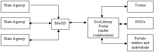
One commonly asked question is whether MeGIS and the GeoLibrary are redundant. They are not. The GeoLibrary maintains no technical staff, using the MeGIS operations structure already in place to serve its needs. At the same time, the public / private structure of the GeoLibrary Board makes it the most technical and policy effective interface between the state and other GIS users.
2. Goals and Accomplishments
2.1 2005 Initiatives / Major Projects 1
In 2005 the GeoLibrary undertook the following projects or initiatives in support of each of the areas of strategic focus:
SF1. To support the development and implementation of statewide data standards to ensure data quality and to enable common use;
- The GeoLibrary Board developed and maintains data standards for parcel data submitted to the GeoLibrary or developed with GeoLibrary managed funds.
- The GeoLibrary Board developed and implemented policies concerning budget authority and relations with private industry, and currently is refining policy regarding the contributions of datasets to the GeoLibrary and the adoption of standards.
SF2. To support the development of a web-based distribution system to facilitate access to statewide data holdings:
- the GeoLibrary is constructing an enhanced web-based portal as its "front door" for public access to statewide data and to facilitate the development of a virtual GIS network linking statewide geospatial data holdings. The GeoLibrary Portal Project was designed and put out to competitive bid in the fall of 2005. The Ionic Corporation was awarded the project with work beginning January 2006 with completion scheduled for 2Q, 2006.
SF3. To support the provision of funding and management for high priority data and database development to encourage community and regional planning, smart growth, and community preservation, the GeoLibrary Board:
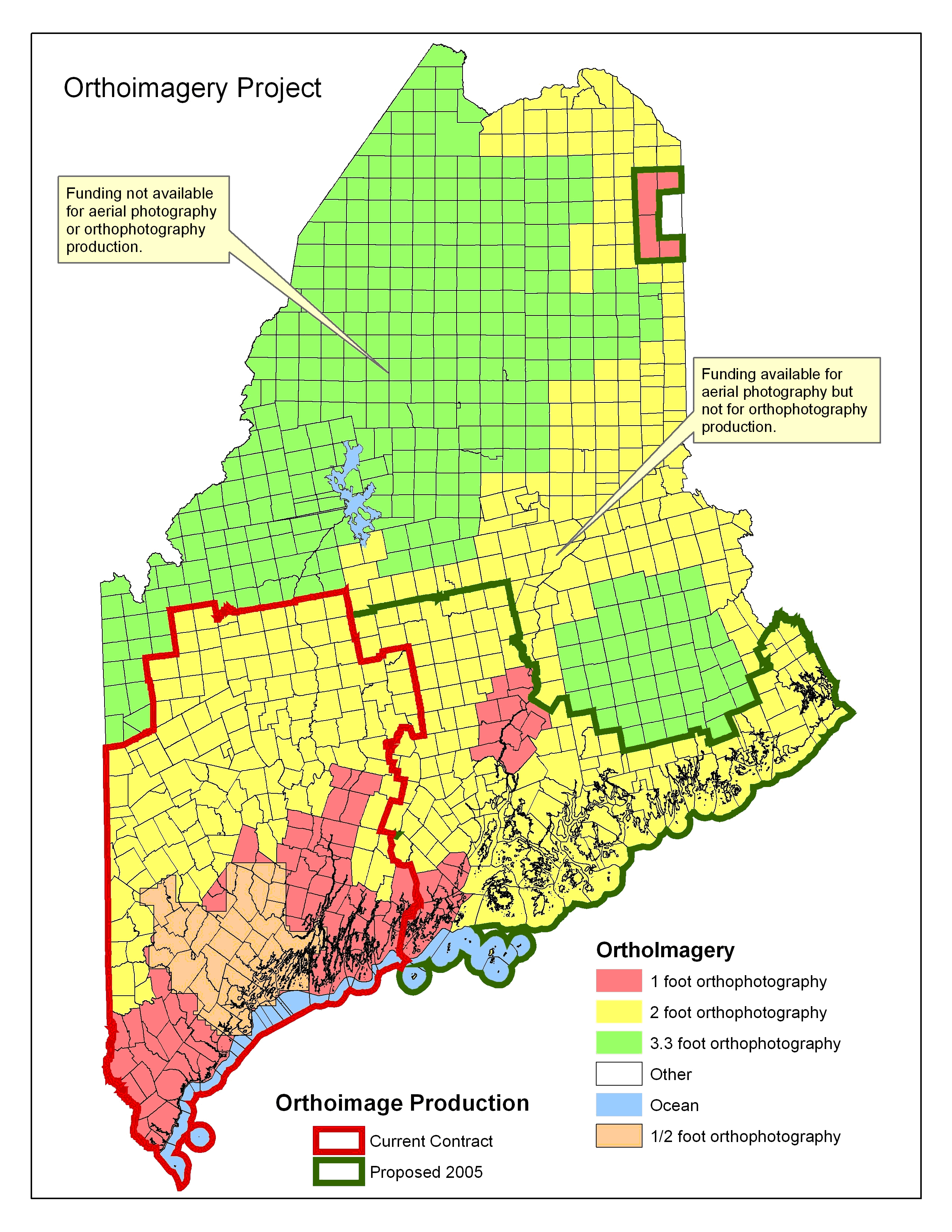
- implemented a $3.2M project in conjunction with the Federal Government to produce digital Orthoimagery for the state's organized townships. Areas now available and those that will be available in 2006 are presented in Attachment C. See Attachment D for a survey summarizing public response (including cost savings) and Attachments E and F for samples.
- developed a grant program budgeting bond funds to digitize property tax maps with awards varying from $1,000 to $10,000. The first round of awards was made in 2004 to 45 towns, with 41 completing their projects on schedule, 3 requesting and receiving extensions, and 1 municipality withdrawing from the program. A second round of awards was announced with some 39 municipalities applying for grants and 29 awards made in January 2006. It is noteworthy that because of the GeoLibrary's unique system of governance, 100% of allocated funds in both grant rounds were distributed to the towns. See Attachments A, B for the 2005 and 2006 award lists.
SF4. To support the provision of coordination, outreach, and education in support of better public use of geospatial data and to enhance Maine's position as a national center for GIS research, education and industrial growth, the GeoLibrary completed a flyer on the GeoLibrary for educational and outreach purposes, a copy of which is included as Attachment G. Presentations were made at to Maine Society of Land Surveyors, three to representatives of Maine County Government, and one to the Maine GIS Users Group (MEGUG).
1. Note that the GeoLibrary's fiscal year ends June 31. All year references, however, are to the calendar year.
2.2 2006 Priorities and Initiatives
Pending funding, the GeoLibrary Board plans to undertake the following projects or initiatives in support of its strategic focus.
| GeoLibrary Ordered Priorities | ||||||
|---|---|---|---|---|---|---|
| Details Follow | Bond Funds | Match | ||||
| Priority | Project | FY07 | FY08 | FY07 | FY08 | NOTES |
1 |
Complete orthophoto project | |||||
Tier B |
$270,000 | $270,000 | Federal Match | |||
Tier C |
$330,000 | $330,000 | Federal Match | |||
begin update cycle |
$250,000 | $250,000 | Likely Federal Match | |||
2 |
Parcel Grants | $750,000 | $750,000 | $750,000 | $750,000 | Municipal Match |
3 |
Conservation Lands Maps | $200,000 | $200,000 | |||
4 |
Zoning Maps Grants | $50,000 | $50,000 | |||
5 |
Update Statewide Land Cover | $100,000 | ||||
6 |
DFIRM Production | $300,000 | $430,000 | $300,000 | $430,000 | Federal Match |
7 |
Development Tracking | $250,000 | ||||
8 |
Build Statewide GIS Network | $150,000 | $150,000 | |||
9 |
Standards, Conformity, and Upgrades Validation | $100,000 | $200,000 | |||
SUBTOTAL |
$2,070,000 | $2,460,000 | $1,320,000 | $1,760,000 | ||
TOTAL |
$4,530,000 | $3,080,000 |
Priority 1: Complete Orthophoto Project and begin the first update cycle
To support the management of high priority data and database development for community and regional planning, smartgrowth, and community preservation, the GeoLibrary implemented a $3.2M project in conjunction with the Federal Government to produce digital Orthoimagery for the state's organized townships. Digital Orthoimagery are aerial photographs that have been processed to function as "photomaps", having the scale and the measurement characteristics of a map with the qualities and characteristics of a photograph. Digital orthophotos are widely used as a base map or backdrop in GIS on which other layers of mapped information can be viewed or analyzed. Because of the "bird's eye view", orthophotos make it easy to view, recognize and understand the relationship of objects on the ground. Digital orthophotos are also used as the source for digitizing ground features to create GIS data layers for specific business functions including road centerlines, building footprints, farm fields, forest types, eelgrass beds and utility & road corridors. Change analysis can then be conducted using orthophotos from different years. This effort represents significant cost savings as the cost of producing orthophotos for municipalities individually would be dramatically greater than the realized cost of undertaking a single, statewide project. New bond funding will allow the completion of this project for the entire state as well as begin the first update cycle in FY08.
This initiative has been extremely well received. Following is a representative quote:
- "Members of the Maine 's Cooperative Forestry Research Unit, a consortium of Maine 's forestland owners representing over 7.5 million acres, are benefiting directly from the GeoLibrary orthophoto program. The digital elevation model (DEM) data that was created with the orthophoto program is currently being used to produce depth to water table maps for over 5 million acres across the state. When complete, these maps will improve forest management by reducing road construction costs, improving harvest operations, enhancing silviculture planning, and identifying wetlands. As much of the forestland being mapped is in northern Maine , development of these maps would be greatly improved by additional photography and the underlying DEM data being completed in areas of northern Maine that have not yet been covered." Robert G. Wagner, Professor and Director, Cooperative Forestry Research Unit, The University of Maine .
Priority 2. Continue the Municipal Grants Program for Digital Property Maps
Also known as cadastral maps, digital property maps show the boundaries of land for purposes of describing and recording ownership and taxation. Property Maps are one of the most important local government information assets, forming a fundamental base for many municipal activities. Although GIS parcel data cannot replace detailed ground surveys, the data assists municipal officials with functions such as accurate property tax assessment, planning and zoning. Furthermore, a digital cadastre provides the most efficient method of collecting and collating geospatial data for infrastructure development and regional planning. A grant program has been developed budgeting bond funds to digitize property tax maps with awards to municipalities varying from $1,000 to $10,000 requiring a minimum 1-1 municipal match for each dollar awarded. The first two rounds of awards is complete with 103 municipalities applying for, and 74 receiving grants. The Board's priority is to meet municipal demand by doubling the grant monies available under this program.
Priority 3. Dvelop Comprehensive Conservation Lands Maps
The State does not have a mechanism to track conservation lands that are in state, federal, municipal or private ownership. Efforts (described below) are currently underway to address this set of data gaps. Without the application of additional technology, however, these systems will not provide an ability to compile or maintain an inventory of all conserved lands.
- One of the requirements of accepting a Geolibrary Parcel Grant is the return of the digital data for inclusion in the state GIS catalog. This is one way to eventually capture information on public access and conserved land at the municipal scale.
- A new focal area for land protection efforts is the preservation of working waterfronts. The Island Institute is developing a database to house data on working waterfronts including information on public access opportunities. The Maine Land Trust Network is currently leading an initiative to develop a database of privately conserved lands. In this effort, land trusts will be invited to provide their data for inclusion in statewide database; specific attributes for each record will include whether the record can be released to the public and whether or not public access is allowed.
The audience of people interested in the status and quality of conserved lands in Maine is large and varied.
- Legislators, municipal officials, voters and members of non-profit conservation groups want to know about the success of the programs in which they have invested, as well as having ready access to information concerning acreage protected, attributes of the properties, visitor numbers and geographic distribution of lands.
- Under Maine statutes and rules, permit reviewers need to know the location and attributes of conserved lands to analyze the potential effects of new development on these properties. Size, location, type of easements or restrictions, habitat types, and viewsheds are types of information needed by this audience.
- New policy directives such as the Maine Coast Protection Initiative (MCPI) and the Coastal and Estuarine Land Conservation Plan challenge conservation organizations to choose projects that address multiple objectives such as public access to the shore, conservation of working lands, and protection of high priority habitat types. Project reviewers have a more complex task when assessing funding proposals, needing to factor in a more diverse set of information. Because each of the seventy MCPI partners has committed to a new framework for strategic land conservation, a variety of public and private conservation organizations would benefit from better evaluative tools.
- Planners and policy makers need to conduct strategic assessments and periodic evaluations of current programs in order to invest resources effectively
- The increasingly more sophisticated eco-tourist desires additional information about conserved lands beyond simple locational information. With more visitors using the internet, a web-based coastal access guide would complement Maine 's efforts to claim additional market share of nature-based travelers.
Funds will be used to update the current conserved lands/public access data and to develop a mechanism to update the data annually. This will include coordination with a Steering Committee; discovery and review of documents held by state and local entities; input of attributes into a database; geolocation of sites as necessary; development of FGDC-complaint metadata; and a mechanism to update the database.
Priority 4. Create a Zoning Maps Grants Program
A comprehensive statewide or regional zoning data layer is an important component of economic development plans, development tracking, build-out analyses and modeling of zoning options. Some limited regional composites of zoning data have been made but municipal zoning does not exist on a statewide basis. Regional or statewide digital zoning maps would be used by realtors, developers, business development groups, conservation organization and municipalities. Zoning data maintained at the municipal level fall into two major types:
- Shoreland zoning, created statewide by statute and general municipal zoning which varies considerably from one town to the next. Zoning data from each community would be automated and submitted for comparison to an established standard and insertion into the GeoLibrary. Partly because it was created by state statute and partly because it is based necessarily on natural features, shoreland zoning is comparatively uniform. This part of the project would lend itself to a regional approach.
- General Municipal Zoning. Zoning maps would be automated with zoning areas represented as polygons with attributes describing the municipal zoning classification. Maine municipal zoning does not have a uniform set of zoning codes. Therefore, as with the digital parcel data, standards will need to be developed by the Geolibrary Board to guide data development. A state standard would not involve removing local codes from the data. The final attribute table would include two fields: 1) municipal zoning code, and 2) state zoning code. Again, data from each individual community would be automated and submitted to the state for comparison to the standard and insertion into the Geolibrary.
The Board would fund a program of grants to create modeled on the Parcel Grants Program to upgrade and submit digital zoning to the GeoLibrary to create a statewide zoning data layer.
Priority 5. Update Land Use/Land Cover
The GeoLibrary used bond funds to provide partial funding for the development of a new Maine Landcover Dataset to assist organizations in planning for growth and monitoring natural resources. Landcover mapping indicates the dominant vegetation or ground cover within a particular 5mx5m square, grouped into areas of two acres or more. This project is tightly integrated with federal efforts to map landcover and imperviousness nationwide at 30-meter resolution, realizing tremendous cost savings. Other contributors to the project include federal agencies ( U S Geological Survey , National Oceanographic Atmospheric Administration, Environmental Protection Agency (Federal) ), as well as state agencies ( Maine Department of Environmental Protection , Maine Department of Transportation, Maine State Planning Office, Maine Inland Fisheries & Wildlife, Maine Drinking Water Program ). The users of land use/land cover data include:
- biologists modeling species habitat for population management
- planners studying growth in Maine
- environmental specialists looking at storm water issues (imperviousness)
- forestry planners studying forest composition and change
- emergency management planners
- meteorologists modeling air emissions
- growth planners assisting siting of new businesses
- municipal governments for their planning needs
Each of the above uses can be accomplished in a more cost effective manner through remote sensing than through field mapping, and having a statewide effort provides an added level of consistency. Updates of this data every 2 to 5 years to assess change over time is key to an effective ROI.
Priority 6. Assist with Digital Flood Insurance Rate Map Production
The losses due to recent flooding events has made the public and every level of government more aware than ever of the significant hazards, risks and costs of occupying land along or near our nation's coastline and rivers. Trends and decisions on where and how to develop in these areas have often not reflected the fact that floods have historically caused more damage and economic loss in the United States than any other type of natural disaster. Yet, it is estimated that more than 50% of the US population lives within 50 miles of the coast or Great Lakes . Yet significant development pressures continue along inland rivers and lakes. It is therefore incumbent upon public and private land use and mitigation planners, state and local economic and community development personnel, and local officials to be able to assess flood hazards and guide development in such a way that will increase its sustainability, reducing future physical and economic losses.
The flood hazard data and maps (Flood Insurance Rate Maps, or FIRMs) created by the Federal Emergency Management Agency (FEMA) are critical tools used by land use and mitigation planners, economic and community development officials, code officers and building inspectors, engineers, lenders, insurance agents, as well as the public to help ensure the appropriateness and sustainability of new and re-development occurring in flood hazard areas along water bodies. Congress implemented the National Flood Insurance Program (NFIP) in 1969, which is now administered by FEMA within the Department of Homeland Security. The Program provides the availability of flood insurance in those communities that join the NFIP and adopt both the FIRMs and FEMA's floodplain development standards. The development standards which are tied to the various flood hazard zones delineated on the maps, reduce the potential and extent of structural damage during flooding events. The flood hazard zones shown on the maps also help identify the level of risk for flood insurance purposes and are one of the factors related to the premium rate structure.
Many of the original flood hazard maps created in the 1970's were updated in the mid 1980's to early 1990's. Since then, FEMA's budget and remapping efforts have been limited by technology and funding, resulting in outdated maps and data. In recognition, Congress has committed to a Five-Year Flood Map Modernization Program, which is FEMA's initiative focused on updating the country's aging inventory of FIRMs, to reflect development changes that have occurred in watersheds and to update mapping methodologies and technologies. The modernized maps will be produced as a truly digital and seamless layer of flood hazard data which will more accurately reflect flood hazard areas for floodplain management / land use purposes and flood risk zones for insurance purposes. The digital FIRMs, or DFIRMs, will:
- better guide economic development, mitigation planning and emergency response;
- provide better information to lenders, insurance agents and the public on issues relating to flood risk and flood insurance; and
- reduce the economic impacts of flooding
FEMA's Flood Map Modernization Initiative also promotes stronger state partnerships in an effort to create efficiencies in the mapping process. Increased state participation in Flood Map Modernization management and mapping activities will help to focus funding on areas of state priority and maximize the utilization of mapping funds. The State Planning Office's Floodplain Management Program (MFMP) is partnering closely with FEMA on the management of Maine 's Map Modernization activities. The Maine Office of GIS has been collaborating with SPO and FEMA to digitally convert flood maps in two ccounties. However, MEGIS lacks the capacity to accomplish this activity for the entire State. The average age of Maine 's FIRMs (19 years old) is significantly older than the national average and nearly half of the State's FIRMs lack detailed flood hazard data. These two factors dramatically increase the cost of creating updated DFIRMs for Maine . Federal Map Modernization funds being received by Maine are not adequate for the State to meet FEMA's metrics. Increasing the State's contribution to the Map Modernization initiative has a positive effect on the level of federal funding and will allow mapping contractors to supplement the mapping currently being done by MEGIS. Without additional funds, Maine will not meet the national goals of the Flood Map Modernization initiative and will leave Maine citizens, communities and professionals with outdated maps that do not accurately reflect the flood hazard and risk zones.
Priority 7. Development Tracking
The following is excerpted from the Final Report of the Development Tracking Steering Committee, March 2005:
"Development tracking involves documenting changes in the landscape induced by human behavior. In its most basic form, development tracking entails monitoring the construction of buildings and the extension of directly related infrastructure such as roads and utilities. It may also entail the study of changes in how lands are used by humans, including changes in land cover related to changes in agricultural and forest management practices, changes in residence patterns from seasonal to year-round occupancy, and the aggregate effects of individual land-use changes on the character of communities.
"Understanding where new development is occurring and where changes in land use and infrastructure are taking place is valuable information for a wide array of stakeholders in both the public and private sectors. For example, land-use planners may use this information to evaluate the effectiveness of existing growth management strategies and design future growth management strategies. Economists may use this information to evaluate changes in real-estate markets, study the location decisions of households and firms, and predict future changes in development. Similarly, community economic development specialists may use this information to evaluate linkages between regional economic trends and changes in growth patterns. Ecologists may use development tracking information to identify natural resources that face significant threats from development and evaluate changes in habitat associated with development. Land conservationists may use this information to manage their holdings and plan for future investments. Local officials may use development tracking information to plan for capital investments such as new schools or roads and changes in service areas such as extensions of police and fire protection areas. In addition, these officials may employ this information when revising local ordinances to maintain the quality of life in their communities. Private firms may use development tracking information to assess the market potential of different areas and plan future investments. Finally, citizens may find this information helpful as they consider changes in their community, strive to retain their community's character, or plan a move to a different community."
The Board will work with SPO and MEGIS to appoint a development tracking implementation committee and task the group with coordinating the data collection and pilot projects as outlined in the Steering Committee's report.
Priority 8. Building a Statewide GIS Network
The Board will develop a virtual network of GIS nodes linked through common standards such as the Open GIS Consortium (OGC) standards for web holdings. The strategy is to implement a grant program whereby organizations that have GIS holdings make the information available using OGC standards. The grant program would be separated into two tiers.
- Tier A - Organizations that already have web enabled GIS data holdings would be eligible for grants up to $5000 to make their GIS data holdings OGC compliant and thus viewable through a variety of desktop GIS applications (e.g. ESRI, MapInfo, Autodesk).
- Tier B - Organizations that have GIS holdings that are not web enabled would be eligible for grants up to $15,000 to implement a web-based GIS server and to provide assistance with making their GIS holdings OGC compliant.
Priority 9. Build Conformity and Validation Tools.
Standards conformity validation applications will allow the State to determine rapidly if the data submitted by any collaborating entity meets the Board standard for that data layer. Current GIS softwares provide very limited validation tools for Quality Assurance/Quality Control of the spatial data and of the related attribute information. Consequently, GIS users, especially state governments, traditionally invest a large amount of time attempting to evaluate the quality of data. Validation tools automate this process, saving staff time and scarce funding. Typically in validation programs, data sets are auto-scanned for spatial errors and attributes outside set parameters; simply put to see if anything "sticks out". If the data passes the conformity test, then it can move forward in the process for eventual inclusion into the GeoLibrary. If the data does not pass, it would be returned to the supplier, perhaps with a report card, so that its deficiencies can be addressed. While automated tools will be important, there will also be a need for accompanying manual quality assurance/quality control procedures.
3. Finances Expenditures through 2005
The GeoLibrary Board serves pro bono , and, as noted, its staffing is funded by arrangement with BIS. The Board was given authority to administer $2,300,000 in State bond funds for GIS capital investments in November 2002. The Board has entered a series of cooperative agreements with Federal agencies to garner the required $1.6 million federal match for the approved bond funds. This effort resulted in a number of federal partnerships that have provided federal dollars for Maine GIS initiatives as noted in the following summary.
| Total Expenditures (spent or encumbered by contract to 12/31/05) | Maine Bond | Federal Match or Grants |
|---|---|---|
| 1. Infrastructure Development | $5,209 | $0 |
| 2. Orthoimagery Project (04-05) | $783,447 | $783,447 |
| 3. Maine Parcel Grants Program (Round 1) | $178,083 | $0 |
| 4. Archive Project | $3,000 | $100,000 |
| 5. GeoLibrary Portal | $110,000 | $0 |
Subtotal |
$1,077,039 | $883,447 |
| Approved by Board vote but not yet encumbered by contract | ||
| 6. Maine Landcover Project | $120,000 | $300,000 |
| 7. GeoArchives Project | $7,708 | $7,708 |
| 8. Parcel Grants Program, Round 2 | $185,988 | $185,988 |
| 9. Orthoimagery Project | $868,216 | $868,216 |
| 10. County GIS User Study | $6,250 | $15,000 |
| 11. Outreach Brochure | $5,000 | $0 |
Subtotal |
$1,193,162 | $1,376,912 |
TOTAL |
$2,270,201 | $2,260,359 |
4. Requested Legislative Action
Although much has been accomplished, at current levels of funding the GeoLibrary will not be able to sustain its mission. The GeoLibrary Board requests that the Legislature approve $4,530,000 in new bond funding in support of statewide GIS development as detailed in the above priority list to include costs for bond administration not to exceed 2% (two percent).
ATTACHMENT A1: Parcel Grants Round 1 Award List
| Standard Grants: 54 Towns Applied - 21 Awarded | Rapid Grants: 27 Towns Applies - 24 Awarded |
|---|---|
| Cape Elizabeth | Anson |
| Casco | Auburn |
| Ellsworth | Bath |
| Falmouth | Biddeford |
| Freeport | Bridgton |
| Gorham | Brooksville |
| Gray | Casco |
| Islesboro | Castle Hill |
| Jackson | Chapman |
| New Gloucester | Cumberland |
| North Yarmouth | Denmark |
| Norway | Fort Kent |
| Oxford | Harrison |
| Paris | Kittery |
| Raymond | Madawaska |
| Rockport | Mapleton |
| Rumford | Mariaville |
| South Portland | Raymond |
| Thorndike | Skowhegan |
| Unity | Stonington |
| Woodstock | Sweden |
| Verona | |
| Woodland | |
| Yarmouth |
ATTACHMENT A2: Parcel Grants Round 2 Award List
| Standard Grants: 36 Towns Applied - 26 Awarded | Rapid Grants: 3 Towns Applied - 3 Awarded |
|---|---|
| Arrowsic | Clifton |
| Bethel | Phippsburg |
| Bowdoin | Whiting |
| Bowdoinham | |
| China | |
| Dover-Foxcroft | |
| Friendship | |
| Hermon | |
| Lincoln | |
| Levant | |
| Lovell | |
| Lyman | |
| Ogunquit | |
| Readfield | |
| Richmond | |
| Saco | |
| Searsmont | |
| Searsport | |
| South Berwick | |
| Standish | |
| Topsham | |
| Turner | |
| Vassalboro | |
| Waldoboro | |
| West Bath | |
| Winsloe |
Attachment B: Map of Orthoimagery Coverage
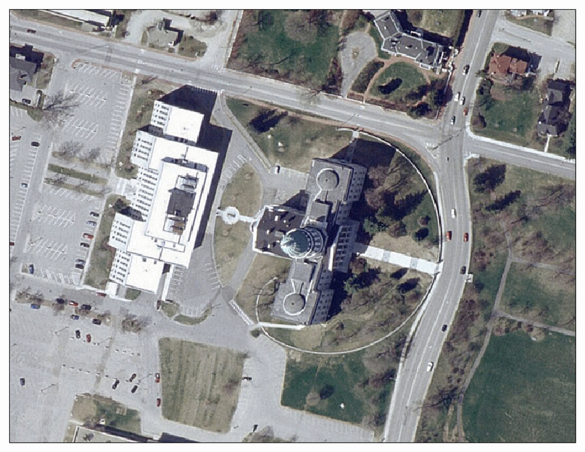
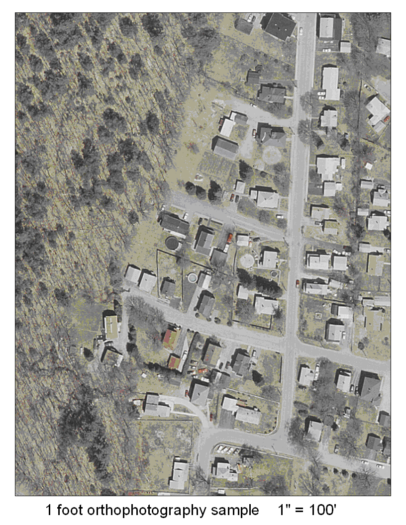
Attachment C: 1' Orthoimagery Sample
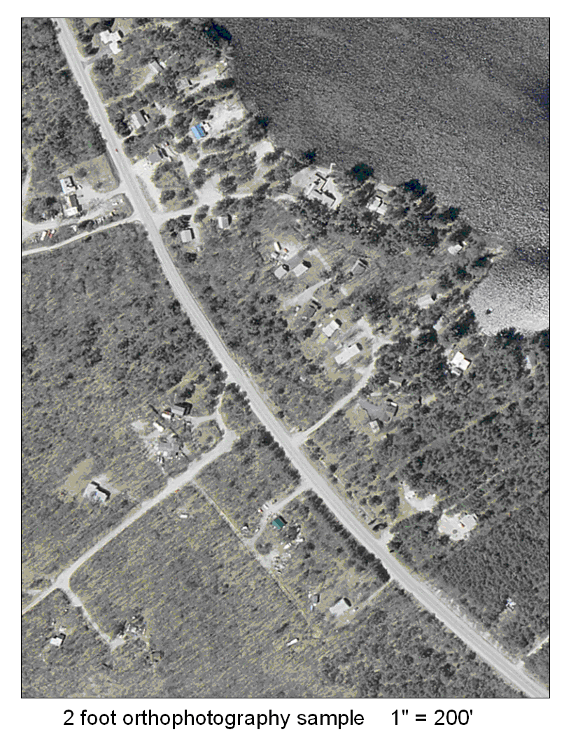
Attachment D: 2' Orthoimagery Sample
F. Public Survey Orthoimage Summary
The organizations that have accessed the orthoimagery supplied by the Maine GeoLibrary to download from the website, used internet browser to view aerial photography and/or brought the aerial photography viewer into GIS software as a data layer can be viewed at: http://www.maine.gov/geolib/orthosurveyresults.htm