Home → Archives → 2009 Meetings → March 18, 2009
March 18, 2009 Meeting Minutes and Agenda
Time: 10:00 to 12:30
Place: Burton M. Cross Building, Conference Room 105.
AGENDA
1. Approval of the February 18th meeting minutes – Chair
2. Presentation of 2nd Draft Strategic Plan for Comment or Approval – Bruce Oswald
3. CAT 3 Project Update – Nancy Armentrout
4. Review of the Unsuccessful Bond Initiative
5. Subcommittee Reports
• Financial – Larry Harwood
• Policy & Marketing – Marilyn LutzGeoPortal System Administrator Responsibility
• Technical
Status of the GeoPortal – Mike Smith
NEXT SCHEDULED MEETING:
Wednesday April 15th , 2009
10:00 a.m. – 12:30 p.m.
Burton M. Cross Building, Conference Room 105.
MEETING MINUTES
Board Members Present
Nancy Armentrout
Michael Smith
Marilyn Lutz
Greg Copeland
Gretchen Heldmann (by phone)
Paul Hoffman
William Hanson, Chair
Daniel Coker, Co-Chair
Greg Davis
Stu Rich (by phone)
Jon Giles (by phone)
Aimee Dubois
Christopher Kroot
Staff
Larry Harwood
Visitors
Vinton Valentine, University Southern Maine (USM), Maine GIS Users Group (MEGUG)
Bruce Oswald, James W. Sewall Project Team
Joseph Young, State Planning Office
Dan Walters, US Geological SurveyThe meeting was called to order at 10:01
1. Approval of the February 18th meeting minutes
The Chair entertained a motion to approve the minutes. Mike Smith moved to approve the minutes as written. Marilyn Lutz seconded. The Board voted 11 in favor, none opposed, the Chair abstaining. The motion carried.
2. Presentation of 2nd Draft Strategic Plan for Comment or Approval
Bruce Oswald of the Sewall Project Team presented the second draft of the Strategic GIS Plan. The presentation is given here in outline form with comments.
What we covered last time
Review project goals.
Strategic planning process.
Document format.
Plan overview.
- Approach/Recommendations
- Developing Champions
- Sustainable funding
- Proposed budget
- Measuring success
Assuming no new funds.
Task 1 – Update & Alignment
- Update & enhance the 2002 Strategic Plan.
- Review & document activities recommended in the 2002 Strategic Plan
- Update the overall strategic plan/approach
- Bring it into closer alignment with NSGIC Fifty States Coordination Criteria.
- Focus on:
- Coordination with local governments, academia, private sector
- Developing sustainable funding sources
- Cultivating political champions.
NSGIC’s Strategic Planning Criteria
1. Strategic and business plans
2. A full-time paid GIS coordinator and staff
3. Clearly defined authority and responsibility for coordination
4. A relationship with the chief information officer
5. A tie into national programs
6. Contracting authority and cost sharing mechanisms
7. An inter-governmental working environment free of "turf wars"
8. A political or executive champion is involved in coordination
9. Sustainable funding mechanisms
10. Statewide coordination efforts that can be a conduit for federal initiatives
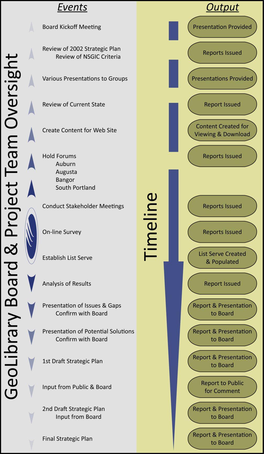
Strategic Planning Process
(graphic on next page)
What we’ll cover today
- What’s happened since December
- Exec Summary/one pager
- Summarize the comments
- Discuss what has changed
- Review work planned for 2009-2010
- Last thoughts
- Decision point - What’s needs to happen next.
There was a brief discussion of funding for the Geolibrary from sources other than state government. If it could be done it would free the Geolibrary from the state budget cycle and the as yet unsuccessful bond requests. It would also be important to have a renewable source of funding for data acquisition programs.
What’s happened since December
- Modified document to respond to comments from Board and Project Team meeting
- Document went out for public comment
- Received a few public and Board comments
- Modified document in accordance with those comments
- Resubmitted Draft # 2 to Project Team (3/6/09)
Comments
- Overall, generally supportive
- Specifics
- Not concise enough
- Need detail
- Get lost in acronyms and technical terminology
- Stress emergency mgt. more
- Useful information (not previously received) on education provided
Changes to draft # 2
- Overall formatting made more consistent
- Diagrams & highlight boxes added and/or modified
- Chapter 1 – reorganized & emergency management bullets added; material eliminated
- Chapter 2 – shortened
- Chapters 4 & 5 – reorganized and modified
- Chapter 6 – modified including new sections on economic realities and highlighting tasks requiring action in 2009 and 2010
- Added an “Abbreviation Guide”
- Appendices – Minor formatting changes. Modifications to G, H & J.
Graphics Additions and Modifications
(next 6 pages)
Budget for the Maine GIS Strategic Plan
Budget for the Maine GIS Strategic Plan Program/Operating Costs
FY09 FY10 FY11 FY12 FY13 FY14 FY15 Program Costs Parcel Grant Program* Integrated Land Records System* Statewide Digital Orthoimagery Program
High Resolution Elevation Data Development of Municipal Service Applications Zoning Maps Grants Land Cover Updating Conservation Land Maps Operating Costs MEGIS Operating Costs Statewide GIS Coordinator Parcel & Data Assistant Biennial Budget Totals: *Note - These numbers need to be coordinated with the final figures from the ILRIS Plan.
Lessons Learned
1. Most users feel that access to updated State and local geospatial data is one of the major needs that must be addressed.
2. Geospatial data creation and maintenance is a need that Maine’s geospatial community looks to the GeoLibrary to provide.
3. There is a significant need for other geospatial coordination activities across the State.
4. We must all learn to adopt to the new economic realities.What Does the Board Need To Do?
1. Increase its coordination activities and secure additional help to do that;
2. Improve its name recognition across the State and to attract champions and funding to complete these important initiatives.
3. Demonstrate how it is making a significant and measurable difference for Maine.
4. Document its accomplishments and plans for going forward.
5. Demonstrate to key leaders in Maine how its plans will make a difference for the State and why they should be funded.
6. Establish a coordinated campaign to promote the use of GIS.
7. Implement the plans quickly and effectivelyComment: The towns are a good source of data to post on the GeoPortal. The advantage would be an economy of scale.
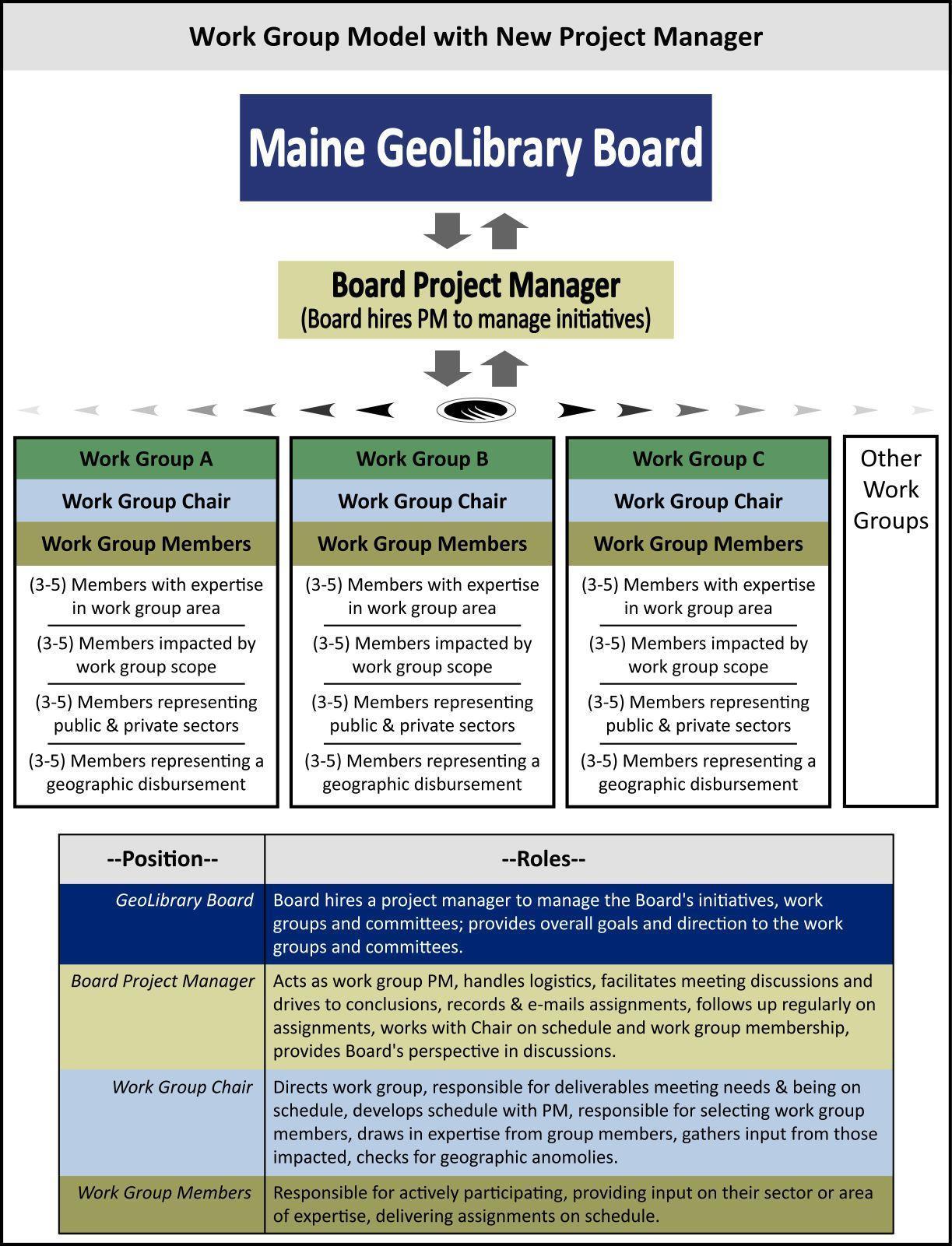
How Can the Board Do It?
- Determine a method to manage the implementation.
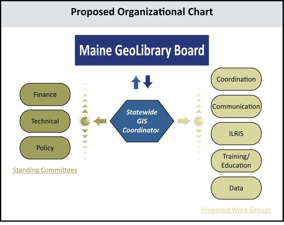
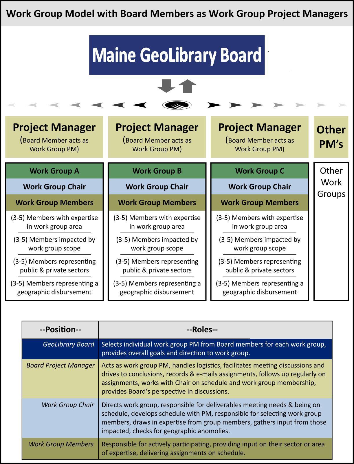
- Establish work groups.
- Implement the GeoPortal.
- Implement the communications plan.
- Develop a set of policies for: sharing; providing access to public and private geospatial data; and notification on new and updated data.
- Perform an annual inventory of geospatial data across the state.
- Develop simple-to-use web service templates for municipalities to use through the GeoPortal.
- Position the Board to be able to implement an integrated land records information system when funding permits.
- Position the Board to be able to create and update statewide geospatial data: orthoimagery, parcel, unified roads, and elevation data.
- Look for opportunities to “sell” GIS benefits.
Look For Opportunities To “Sell” GIS
- Broadband Mapping
- Stimulus Package
Several examples of other state’s approaches to marketing GIS were displayed. Bruce also displayed examples of Maine’s internet based stimulus fund tracking.
Task Highlights for 2009
April – June
- Determine Board’s best strategy for managing the initiatives.
- Select work group chairs and work group members for the Coordination, Communication, Data, ILRIS, and Training/Education Work Groups. In addition, add members to the Technology and Finance Committees.
- Finalize work group missions, deliverables and schedules.
- Hold work group “kickoff” meetings.
- Hold focus group meeting to identify potential champions.
- Launch the GeoPortal.
- Develop an announcement of all GeoLibrary standards and place announcement on the List Serve and on the web site.
- Establish a “What’s New” section on the web site.
- Initiate monthly “News Blips.” Post on the List Serve and the “What’s New” section of the web site.
- Develop plan to recruit champions.
July – September
- Develop policy to inventory State agency and local government geospatial data.
- Develop policy for notification of new or updated geospatial data via the List Serve and web site.
- Establish a “Training/Education” area on the web site. Encourage GIS trainers, universities and other educational organizations to post training educational opportunities on the List Serve and the web site.
- Initiate a program to encourage county and local government to post and share data through the GeoPortal.
- Develop campaign across the State to help others improve their GIS capabilities and lower the barriers to implementing and using geospatial technologies.
- Establish a coordinated campaign to promote the use of GIS in State, county and local government as well as prominent private sector companies.
- Initiate process to recruit champions.
October – December
- Inventory State agency and local government geospatial data. Post results on the website.
- Provide monthly summaries of new data and data updates on the List Serve and the web site.
- Encourage data developers to post data development plans on the GeoLibrary List Serve. Post data development plans on the web site.
- Provide training to select high school teachers as part of a pilot program to enable them to use GIS to improve their ability to teach courses.
April – June
- Work with the CIO, State Agency Stakeholders, MEGUG, and MMA to encourage all application developers to post application development plans on the GeoLibrary Board List Serve prior to starting work and encourage application sharing/partnerships where practical.
- Develop budget proposal for next budget cycle.
- Integrate champions into plans to obtain sustained funding.
July – September
- Develop presentations, one-pagers and other documentation/demonstrations needed to sell initiatives.
October – December
- Coordinate budget activities with the CIO and MEGIS.
- Initiate a training program to help users to take advantage of Google or Virtual Earth.
Last Thoughts
- Provide better access to state agency and local government geospatial data. Offer same opportunity to academia, not-for-profits and the private sector.
- Put forth a significant effort to coordinate geospatial data and application development, training and other activities across the State.
- Establish an on-going program to provide and maintain new and existing statewide geospatial data.
- Promote the use of GIS to those outside the geospatial community to save money and improve services in both the public and provide sectors across the state.
Next Steps
- Determine a method to manage the implementation.
- Establish work groups.
- Implement the GeoPortal.
- Implement the communications plan.
3. CAT 3 Project Update
Nancy Armentrout lead discussion of the Strategic Plan just presented. This was the second draft of the plan and part one of the CAT 3 Grant, the second part being the Integrated Land Records Information System ( ILRIS). The first question to the Board was if approval of the Plan be done by May. It was immediately suggested that the Board be given 2 weeks to review the current draft. It was also suggested that the draft Plan be put out for public comment. The consensus seemed to be that public comment should follow a careful, full Board review.There was a wide ranging discussion of the Strategic Plan and matters related to it. There was much consideration of the possibility of engaging a Geolibrary GIS Coordinator as the Board members all felt they had no time to deal with so many tasks. The opposite position was that no money was forthcoming for a Coordinator and the Board members should split up tasks between them. Dan Walters and Mike Smith also indicated that their respective jobs included responsibilities which could address a good portion of the Geolibrary’s coordination needs. It was also suggested that some tasks could be done by the Geolibrary stakeholders and perhaps other volunteers.
It was eventually decided to create a Summary Strategic Plan. This would be more of an action plan revised and shortened from sections of the full Plan (in particular Chapter 6). Nancy and Marilyn Lutz agreed to try drafting this, if possible in time for the next meeting. This document might well be shared with the public. Nancy asked if the Board could accept the Strategic Plan at the next Meeting.
Christopher Kroot moved that the Board submit all comments on the draft Strategic Plan to Will Mitchell (Project Manager) by March 31 and the plan be ready for approval at the April meeting. Marilyn Lutz seconded. The Board voted 11 in favor, none opposed, the Chair abstaining. The motion carried.
Nancy also reported that the ILRIS part of the project was in revised draft form. The project team is working on the functional specifications. The plan is to have something the Board can review by the May meeting. She thanked everyone for their help and considerable input.
4. Review of the Unsuccessful Bond Initiative
Mike Smith reported that the Geolibrary bond initiative did not make the cut into the Governor’s bond package. Mike Reported that Chief Information Officer, Richard Thompson is not convinced that bonds are the way to fund the Geolibrary. He thinks a better way might be to fund some of the Board’s priority acquisitions by “lease purchase” agreements. With these instruments, the cost is paid off over a period years and funds may be easier to obtain.Mike handed out a 2 page exposition on a proposed US Geological Survey coastal LIDAR collection for all of New England. This would partner the states, USGS and the Federal Emergency Management Agency in a 4 to 6 year project at a cost of about $6M. Possibly this could be a case for a lease purchase to put up a small amount of money as match. He hoped the Board would at least support the proposal and perhaps contribute a token amount of funding.
Mike Smith moved to have the Geolibrary Board support the proposal for LIDAR for New England. Greg Copeland seconded. The Board voted 11 in favor, none opposed, 2 abstaining. The motion carried.
Joe Young, the State Planning Office floodplain mapping expert gave a brief dissertation on the proposed LIDAR project. Federal Emergency Management Agency Region 1 (New England), always supportive of regional efforts and very interested in flood data collection, is on board. USGS has some funding to collect LIDAR and the project would derive considerable funding from that.
Mike Smith moved to appropriate up to $20,000 for the LIDAR project. Stu Rich seconded.
In the discussion that followed the Board was divided on the issue. Those in favor argued that this was token amount, yet a sign to the Federals that Maine was serious about the proposal. Those opposed argued that it was unwise to appropriate funds, given the Geolibrary’s financial status, and without knowing how much others would be willing to pay or if the project would go forward.
Mike Smith amended his motion to appropriate up to $20,000 for the LIDAR project, conditional on Federal funding being available. Stu Rich seconded the amendment. By roll call the Board voted 8 in favor, 4 opposed, the Chair abstaining. The motion carried.
5. Subcommittee Reports
Financial
The financial sheet had one change. At the last meeting $13,000 had been appropriated to buy servers for the GeoPortal. This left a total of $62,370.50 remaining as unencumbered.Policy & Marketing
Marilyn Lutz read and explained the draft policy on GeoPortal System Administrator Responsibility. This was in 5 parts and each was assigned a number for the moment to aid discussion: 1. Server Management, 2. User Support. 3. Metadata Database, 4. Web Maintenance, 5. Changes in the GeoPortal System. Discussion centered on what organization would be responsible for each part.There was some discussion of the Administrator doing part 3 as opposed to larger number of ‘data stewards’ at the portal nodes. It was thought by some that getting municipalities and others to make FGDC compliant metadata was unlikely but the Administrator would not be able to do it for them. Parts 1 & 4 were thought to be the responsibility of the portal hosting site, most probably University of Southern Maine (USM). Part 3 would be handled by the Administrator and also possible part 4 depending on technical issues. Part 1 would also include security and passwords. Part 5 it was though could be left to the Technical Committee if the changes were small but brought before the Board for approval if the changes were substantial. This will be discussed again at the next meeting.
Technical
Christopher Kroot and Mike Smith reported that the GeoPortal was progressing at USM using GeoNetwork, an open source portal software described at the last meeting. The portal is much more functional than indicated by the demo, which suffered technical problems, given at the last meeting. The goal now is to finalize the portal.Some wished to speak quite frankly and ask why the Environmental Systems Research Institute (ESRI) portal software was dropped in favor of GeoNetwork without the Board voting on it. The response was that perhaps it should have been, but ESRI had completely changed their application in the newest version. The new version ( 9.3) did not do what was wanted and had a new operating system. The Technical Committee proceeded as they though best given the Board’s general outline of what the GeoPortal should be.
It was pointed out that there still exists the list of functional specifications for the portal, dating from the last contract. Apparently a new functional list was created some time ago but was not immediately available. The Technical Committee will look into this and certainly the functional list will be used to test the portal.
Christopher suggested that the Technical Committee be split into ‘general’ and ‘technical’ subcommittees. The technical group would have detailed knowledge of technical details and the rest could focus more on overall functionality. At present he asked for a listing of the committee members. The membership at present is as follows: Christopher Kroot, Chair, Greg Copeland, Gretchen Heldmann, Nancy Armentrout, Mike Smith and Stu Rich. The Chair asked the Technical Committee to come back with a recommendation on any new configuration.
The meeting was adjourned at 12:31