Home → Archives → 2009 Meetings → Jan 21, 2009
January 21, 2009 Meeting Minutes and Agenda
Time: 2:00 to 4:00 PM
Place: Burton M. Cross Building, Conference Room 105.
AGENDA
1. Approval of the November 20th meeting minutes – Chair
2. Approval of the December 17th meeting minutes - Chair
3. Integrated Land Records Information System – Rich Sutton (45 minutes – 1 hour)
4. Image Services – Mike Smith (15 – 20 minutes)
5. CAP grants
6. Subcommittee Reports
- Financial – Larry Harwood
- Policy & Marketing – Marilyn Lutz
- Submission of Data Sets document
- Technical
- Status of the GeoPortal – Mike Smith
7. Elections for Chair & Co-Chair 2009 – All
NEXT SCHEDULED MEETING:
Wednesday, February 18th, 2009
10:00 a.m. – 12:30 p.m.
Burton M. Cross Building, Conference Room 105
Meeting Minutes
Board Members Present
Nancy Armentrout
Michael Smith
Robert Marvinney
Marilyn Lutz
Gretchen Heldmann
Kenneth Murchison (by phone)
Paul Hoffman
William Hanson, Chair
Daniel Coker, Co-Chair
Greg Davis
Stu Rich ( by phone)
Jon Giles
Aimee Dubois (by phone)
Staff
Larry Harwood
Visitors
Bruce Oswald, James W. Sewall Co Project Team ( by phone)
Rich Sutton, Reference Standard, JWS Project team
James Page, CEO James W. Sewall Co. (by phone)
Steve Harmon, First Wind, Maine GIS Users Group (MEGUG)
Vinton Valentine, University of Southern Maine, MEGUG
Joe Young, State Planning Office
The meeting was called to order at 2:04 p.m.
1. Approval of the November 20th , 2008 meeting minutes
The Chair entertained a motion to approve the minutes. Mike Smith
moved to approve the minutes as written. Marilyn Lutz seconded. The
Board voted 10 in favor, none opposed, the Chair abstained. The motion
carried. (The Chair traditionally abstains unless needed to break
a tie.)
2. Approval of the December 17th, 2008 meeting minutes
The Chair entertained a motion to approve the minutes. There were
two corrections: Section 2 should include words to the effect that
the project team was not ready for the ILRIS presentation ; and the
minutes should reflect that Jon Giles attended by phone. Mike Smith
moved to approve the minutes as thus amended. Dan Coker seconded.
The Board voted 10 in favor, none opposed, the Chair abstained. The
motion carried.
3. Integrated Land Records Information System
Richard Sutton of the James W. Sewall Team gave his Interim Briefing on the Maine Integrated Land Records Information System. The presentation is given here in outline form based on the Power Point slides with any accompanying questions, answers and comments.
-
ILRIS: System Objectives
1: More complete and efficient collection and maintenance of standardized, multi-purpose land ownership and rights data
2: Better, simpler access to data by users at all levels of government and the private sector
3: Integration of numerous data feeds into a comprehensive parcel frameworkProject Phases
• Research - what is being done now and what do users need?
• Concept – how to translate those needs into services or products
• Specification – who does the work and how much will it cost?
• Promotion – who needs to know about the system to help grow it?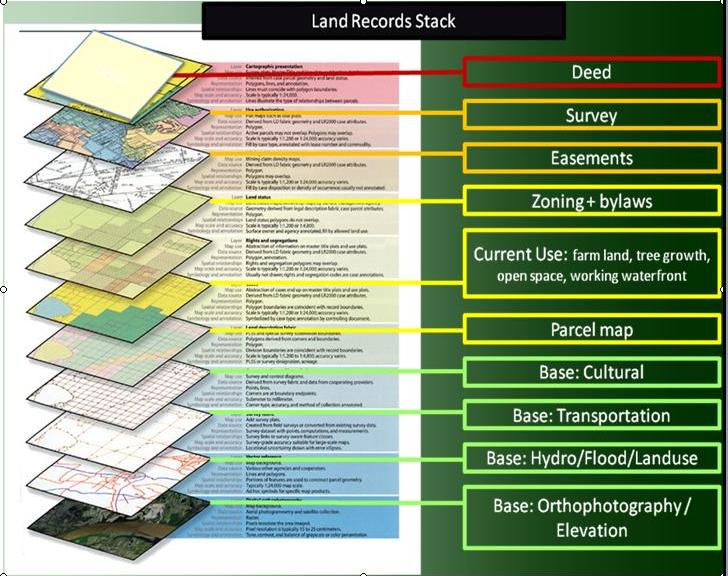
ILRIS Data Components. This was intended to be only an overview. The graphics and small text are not visible at this scale.
Research Findings Highlights: Parcels Completion
• Maine has arguably the nation’s most complicated parcels landscape
• Most maintenance jurisdictions
• Fractured taxation and ownership data tracking responsibilities
• 780,000 total parcels
The number of towns with parcels digitized is fairly small but they
represent most of the municipalities with the largest numbers of parcels.
The bigger numbers add up faster.
Maine has the “worst case scenario” for putting together parcel data because Maine property tax records are maintained by the towns and the ownership records are maintained by the counties. Maine has a very small number of parcels compared to other states; Maine’s 780,000 parcel total is the equivalent of a typical county in some other states.
Research Findings Highlights: Parcels Completion (cont.)
• 200,000+ parcels currently standard compliant
• 100,000+ parcels digital (close to standard)
• 150,000+ parcels digital (significantly substandard)
• 300,000+ parcels must be digitized from source
• 550,000+ parcels required for statewide coverage_____________________
• Estimated cost: $1.6 - $2m to composite
These numbers generated some confusion with the Board members. It
was pointed out that nothing added up mathematically and Board members
had trouble seeing the bottom line. Rich explained that these were
just estimates and rough at that. The important numbers are that out
of roughly 1 million parcels, about half are not available in digital
form.
Research Findings Highlights: Parcels Maintenance
• Maintenance across the state is non-uniform and sporadic; the best records exist where use is greatest
• No current update to repository data for standard compliant towns
• Maintenance regime for standards towns deemed critical: as important as bringing additional towns online
• Promoting more effective parcel data maintenance will require incentives and coordination
There is no mechanism for updating the municipal parcel data at the
state level. The exception is Maine Revenue Services which administers
the unorganized township parcels.
Research Findings Highlights: Data Integration
Municipalities
• Source for most parcel geography
• Assessors first and primary users
• Use expands from assessing to other departments: public works, police, fire, planning, schools, conservation + recreation, health, zoning, inspectional services
• Largest 15 Maine communities represent 20% of total parcels; top 75 towns contain 50% of all parcels.
Research Findings Highlights: Data Integration
County Registries
• Integration of Registry data anchors parcels to deeds
• Integration supported by Registers
• Potential advantages for more efficient and more contextual searching
• Efficiency and accuracy advantages in linking “low standard” parcels to registered survey plans
• 120,000 plans in 18 Registries
Rich noted that it is difficult for the registries to see the value
of an integrated records system to their day to day operations. Two
graphics were shown demonstrating how digital parcel data can be “rubber-sheeted”
to fit the more accurate survey data.
Research Findings Highlights: Data Integration
Maine Revenue Service
• LURC parcel management
• 28K properties, 10m acres
• Inventory of Classified lands
• Tree Growth, Farmland, Open Space, Working Waterfront
• Exempt properties
• Municipal parcel counts (accurate ones)
MRS data would require a lot of work to make it “GIS ready”.
This is mostly because there is not a one-to-one correspondence between
the database and the spatial data.
Research Findings Highlights: Data Integration
State Agencies
• Transportation:
• Heavy use in ROW corridors;
• Considerable orphaned resources
• Potential source of corridor survey data
• Environment: Department of Environmental Protection/Department of Conservation Active users; require accurate ownership;
• SPO, DECD, PUC, MSHA, Archives
Statewide parcel data would be of more value to state agencies than
probably any other group.
Research Findings Highlights: Data Integration
• Commercial
• Surveyors
• Mapping/GIS
• Revaluation Companies
• Title Attorneys
• Web vendors
• Non-profit, Non Governmental Agencies, Land Trusts
• Regional Councils and Planning Agencies
• Educational
• Private + Public
Research Findings: General Observations
• Data privacy as a concern has significantly diminished from the levels prevalent during the 2001-2002 Resolve 23 study. Data privacy is a major issue but it is less of an issue than a few years ago, because of the advances in dissemination of data thru the internet.
• Wide and growing appreciation of parcels as a vital data asset for infrastructure management and planning
Access to available data still much impeded: inexpensive/free tools
are not being leveraged. The towns and registries are not trying to
use even the free software available. This is restricting access to
data they could use.
Research Findings: General Observations (cont)
• Access to Registry data (deeds and surveys) is frequently described as expensive and inefficient despite being available via web.
• Deteriorating economy presents huge and growing hurdle to likelihood of securing resources for “luxury” technology
• Federally significant lobbying is underway to guide stimulus dollars to complete parcels nationally
Although the initial investment in an ILRIS would be high, maintenance
after that would be minimal.
Research Findings: Comparative Findings
• 19 states have converted more than 80% of their parcels to digital
• At least 8 states (all in the southeast) are currently working to integrate parcels into a statewide composite – all are county-based with higher parcel counts;
• Numerous commercial aggregators are accelerating trends: Navteq, TeleAtlas, First American, Sidwell
Research Findings: Identified Benefits
For Local Governments:
• Provides base maps, inventories for multiple departments
• Accelerates land-centric searches
• Makes data more transparent – improves public attitude toward government
• Encourages coordination
• Provides common operational picture
Research Findings: Identified Benefits
For State Government / Agencies:
• Provides exhaustive fabric of land ownership – ideally with definitive tie to deeds
• Encourages coordination
• Provides common operational picture
Research Findings: Identified Benefits
For Federal Govt, NGA, Commercial Interests:
• Provides standardized data for mapping and statistics; formalizes inventories
• Provides faster access to land titles
• Provides exhaustive fabric of land ownership – ideally with definitive tie to deeds
• Encourages coordination
• Provides common operational picture
The hot topic with federal agencies now is “fraud avoidance”.
After the gulf hurricanes, property markers were literally washed
away and it was impossible to determine ownerships. This adversely
affected relief payments officials struggled to properly identify
owners. The same can be said for other natural disasters especially
large fires as seen in the west recently. Enhanced mapping may help
avoiding fraud arising during such events.
Funding – Extremely difficult time
• CAP grant initiatives being pursued
• Digital survey standard
• Bond funding being pursued
• Governor meeting with foreclosure team
• Commercial interest in parcels as marketable commodity
Political difficulties in initiating a transfer tax or recording fee
surcharge fee approach Though has been shown to be very effective
elsewhere
This concluded the presentation.
Q: How bad is Maine’s situation compared with other states?
A: It’s pretty bad because of the diverse mapping entities and
the lack of money. That said it is hard to judge. For example, Maine
has far fewer parcels than other states. A large part of the state
is held by a few owners, and the unorganized areas – over half
the state - are mapped already.
Q: The research part looks very good. What about the second part?
A: The Conceptual Framework. There are documents out for review now
and there will be more work ahead to finish up.
4. Image Services / Status of the GeoPortal
Mike Smith reported that the GeoPortal was being constructed using
an open source software called GeoNetwork. The serving of images (i.e
aerial imagery, scanned topo sheets, etc.) thru the portal would require
two additional servers. These would probably reside at University
of Southern Maine. Informally, would the Board consider buying two
more servers?
Q: Didn’t DEP donate two servers for the portal?
A: Yes, but they are too old to use for this purpose.
Q: How many servers did the Board buy previously?
A: Only two servers were approved. Larry will check the past minutes
for us on that.
Q: Why would these servers reside at USM and not OIT?
A: They have more experience with GeoNetwork and OIT/MEGIS have none.
There was a frank discussion of the direction the GeoPortal development was taking. There were suggestions that GeoNetwork might be another unworkable choice. Mike explained that of the choices available that was the best. The alternative was to use ESRI version 9.2 which is obsolescent or ESRI version 9.3 which he described as the least desirable choice.
There was also much concern about devolving too much responsibility for the portal’s functioning on USM staff and especially students, transients by their nature. Unfortunately OIT does not support the platform needed to run GeoNetwork nor is there anyone at OIT versed in the operating system or GeoNetwork itself. USM has agreed in writing to host the application in their production facility at no charge.
The Chair asked the Technical Committee to examine all these issues and report back all relevant information to the Board at the next meeting. Christopher Kroot being on leave, the Chair appointed Mike Smith as the interim chair of the Technical Committee.
Mike also reported that he has applied for a grant to increase storage
on the imagery servers. The current storage in Oracle, which operates
the Internet Mapping Sites, is very expensive and there is no more
space available in any case.
Q: Is non-state imagery going to be served too?
A: Yes. It already is.
5. CAP Grants
The only Cooperative Agreements Program grant application was for
the Category 1. This is a $25,000 grant for Metadata Trainer and Outreach
Assistance to “provide assistance to organizations with NSDI
expertise knowledge and experience in assisting other organizations
with the training and implementation of metadata, clearinghouse or
web mapping services.” The match is “soft match”
of services in kind only not cash. If awarded that would require participation
by Board members and staff.
It is thought that next year would be good for a Category 6 application. This is a grant for “FGDC Standards Development and Implementation Assistance and Outreach” of up to $25,000. The Board would need an FGDC appointee to help with the application. The Category 7 grant on examination did not fit any Geolibrary programs so it was dropped altogether. The CAT 7 grant was a “Demonstration of Geospatial Data Partnerships across Local, State and Federal Government” for $75,000 with a 50% match.
6. Subcommittee Reports and Election
Subcommittee reports and the election of chair and co-chair were tabled
to the next meeting.
Further Business
Marilyn Lutz reported that she has applied for a grant to establish
ISO standard, simplified metadata for museums and libraries to make
it easier for their staff to enter metadata. The project aims to facilitate
the integration and publication of geospatial data holdings from numerous
active Maine repositories that currently lack the technology or expertise
to make their data generally accessible. She requested a required
letter of support from the Board. The Board unanimously assented to
the Chair signing such a letter; he and Marilyn will draft one. The
Chair will also become an Advisory Board member of an ISO/FGDC board.
The Co-Chair asked for an update on the Geolibrary bond proposal. The Board and its supporters have done all they can, and the funding request is now in the hands of Dick Thompson the Chief Information Officer. At last report the Geolibrary bonding was “still in the game”.
The meeting was adjourned at 3:56 p.m.