Home → Fish & Wildlife → Fisheries → Fish Tag Reporting
Fish Tag Reporting
Congratulations on catching a tagged fish!
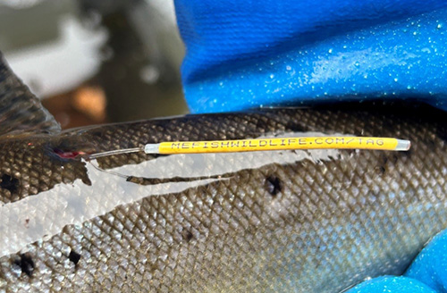
Fish biologists use "T-bar tags" or "Floy tags" to mark fish species across the state, helping them gather valuable data on Maine's fish populations. Each tag contains a unique identification number, allowing biologists to track individual fish through angler reports. If you catch a tagged fish, please take a clear photo of the tag's ID number to report it later.
These tags are not transmitters or GPS-enabled. The information gathered from "Floy Tags" relies entirely on public reporting. Your participation plays a vital role in helping biologists study fish growth, survival, catch rates, species abundance, and movement patterns. All data collected is confidential and used solely to support efforts to manage fish populations, ultimately enhancing the fishing experience for everyone.
When reporting a tagged fish, anglers are asked to provide the following information:
- The tag ID number
- Whether the fish was harvested or released
- The fish's length
- The location where it was caught
Current study areas include Mooselookmeguntic Lake, Wilson/Webb Lake, Kennebago Lakes, and Pushaw Stream area, read more about the study areas below.
Current Study Areas
Mooselookmeguntic Lake (500 Tagged Wild Salmon and Brook Trout) and Kennebago Lakes (75 Brook Trout)
In the spring of 2023, Rangeley regional fisheries biologists, with multiple partners and dedicated volunteers, launched a three-year study to learn more about the wild brook trout and landlocked salmon populations in two major study areas: Mooselookmeguntic Lake and the Kennebago Lakes. Mooselookmeguntic Lake, part of the chain of Rangeley Lakes, is within the top ten largest lakes in the state spanning 16,300 acres.
Mooselookmeguntic Lake is also Maine's largest Heritage Water (PDF), supporting self-sustaining wild populations of brook trout and landlocked salmon. The lake has four major tributaries; the Kennebago River, Cupsuptic River, Bemis Stream, and Rangeley River, which together provide dozens of miles of high-quality habitat. The Kennebago Lakes study area, located just north of Rangeley, includes Little Kennebago Lake (190 acres), Kennebago Lake (1,764 acres), and the Kennebago River. This watershed stretches 30 miles from the headwaters of the river to its confluence with Mooselookmeguntic Lake. The Kennebago Lakes are managed as a separate study area due to a dam on the river that prevents fish passage. These lakes are also designated Heritage Waters (PDF) and support robust wild brook trout and landlocked salmon populations.
The primary objectives of this study are to better understand seasonal fish movements, key spawning and staging areas, thermal refuge use, catch rates, harvest rates, and growth rates. The information gathered will help fisheries biologists effectively protect and manage wild brook trout and landlocked salmon populations while ensuring opportunities for recreational anglers. This multifaceted project uses two types of tagging methods: surgically implanted radio telemetry tags and external floy tags. Radio tags are inserted into a fish's abdomen and allow biologists to track movements using telemetry techniques. Floy tags, small plastic external tags placed near the dorsal fin, serve as the citizen science component of the study, relying on anglers to report tagged fish when they are caught. Over the three-year study, biologists have deployed 153 radio tags and 586 floy tags in brook trout and landlocked salmon in the Mooselookmeguntic Lake study area. Biologists have also deployed 72 radio tags and 87 floy tags in brook trout in the Kennebago Lakes study area.
Across both study areas nearly a hundred anglers have already reported catching floy tagged fish. For years to follow, floy tagged fish from this study will be within Mooselookmeguntic Lake, Kennebago Lake and connected tributaries. If you catch a tagged fish, please report the tag's ID number via the form above. These angler reports provide valuable information that enhances our understanding of these populations and supports effective fisheries management.
Wilson/Webb Lake – 875 tagged hatchery Brook Trout
Fisheries biologists are conducting a genetic strain evaluation of stocked brook trout in Wilson Pond and Webb Lake in Franklin County. This study is conducted through the use of floy tags, angler participation, and winter angler surveys to better understand how different genetic strains of hatchery raised brook trout perform in these waters.
Maine's state hatcheries raise three distinct brook trout strains: the Maine Hatchery Strain, the Kennebago Strain (sourced locally from Kennebago Lake), and a cross of the two. Different strains can exhibit unique behaviors, growth patterns, and survival rates depending on the habitat in which they are stocked. For this study, fisheries biologists partnered with state hatcheries to stock equal numbers of all three strains in both waters in 2024 and 2025. Each strain was marked with a unique identifying fin clip, and a subsample from each strain received floy tags prior to stocking. A total of 1,775 hatchery brook trout have been stocked with floy tags in Wilson Pond and Webb Lake.
The objective of this study is to determine which strain performs best in each lake based on angler catch rates, growth rates, and overall survival or holdover. The results will help biologists optimize stocking strategies and enhance these fisheries.
Anglers fishing on Wilson Pond or Webb Lake are encouraged to report any tagged brook trout they catch by submitting the ID number printed on the tag using the form above; this data is vital to the success of this study. Since stocking in 2024, just over a hundred floy tagged fish have been reported.
In addition to angler reports, fisheries biologists will conduct winter angler surveys (also known as creel surveys) on both lakes throughout the ice-fishing season, interviewing anglers and collecting essential trip information and biometric data (e.g., length, weight) from fish caught.
Pushaw Stream (Pushaw Lake, Little Pushaw Pond, Perch (Mud) Pond, Stillwater River, Penobscot River) – 230 Northern Pike
Northern pike, a non-native invasive fish, was first documented in the Pushaw Lake drainage around 2003. At that time, the Department set trap nets yearly in the spring spawning season to capture and remove as many northern pike as possible, to suppress the population. In 2019, the suppression program ended due to the extensive costs and staff time associated with ongoing manual removal efforts. The Department planned to return several years later to monitor the population post-suppression.
In the Spring of 2025, Enfield regional fisheries biologists and additional volunteers returned to Pushaw Stream to capture and tag spawning northern pike. The objectives of this study include the monitoring of individual movement through the drainage and to obtain growth rates for these invasive fish. Northern pike were captured in trap nets, a live trap that allows the release of fish once biologists have collected biometric data (length, weight, sex, etc.). Orange external floy tags were placed into the fish, near the dorsal fin. Some fish also received a green tag without a number, allowing biologists to monitor tag retention on recaptured fish.
Biologists tagged and released 235 northern pike in 2025. Of these, 98 were female, ranging from 21-41" in length and 2-20.6 pounds. Males represented 119 of these fish, ranging from 16-32" long and 0.6-8.2 pounds. The remaining 18 fish were of unknown sex or sexually immature. The Department plans to deploy additional tags in coming years and continue to attempt to recapture tagged fish. To date, few tags have been reported and those that have represent little movement from initial capture locations.
Anglers are encouraged to provide valuable information for the study by reporting tagged fish with the unique identifing number using the form above.