This page is a portal to National Weather Service information. The National Weather Service Gray serves Southern and Central Maine: Androscoggin, Cumberland, Franklin, Kennebec, Knox, Lincoln, Oxford, Sagadahoc, Southern and Central Somerset, Waldo and York Counties. The National Weather Service Caribou serves Northern and Downeast Maine: Aroostook, Hancock, Penobscot, Piscataquis, Northern Somerset and Washington Counties.
The National Weather Service products linked here for reference are the last issued version, which may be for a past event. Always check the issue date of the product you are viewing.
- Statewide
- NWS Gray
- NWS Caribou
- Regional
- Climate
Weather Zones
- Northwest Aroostook County | with Graphics
- Northeast Aroostook County | with Graphics
- Northern Somerset County | with Graphics
- Northern Piscataquis County | with Graphics
- Northern Penobscot County | with Graphics
- Southeast Aroostook County | with Graphics
- Northern Oxford County | with Graphics
- Northern Franklin County | with Graphics
- Central Somerset County | with Graphics
- Central Piscataquis County | with Graphics
- Central Penobscot County | with Graphics
- Southern Oxford County | with Graphics
- Southern Franklin County | with Graphics
- Southern Somerset County | with Graphics
- Southern Penobscot County | with Graphics
- Interior Hancock County | with Graphics
- Central Washington County | with Graphics
- Interior York County | with Graphics
- Interior Cumberland County | with Graphics
- Androscoggin County | with Graphics
- Kennebec County | with Graphics
- Interior Waldo County | with Graphics
- Coastal York County | with Graphics
- Coastal Cumberland County | with Graphics
- Sagadahoc County | with Graphics
- Lincoln County | with Graphics
- Knox County | with Graphics
- Coastal Waldo County | with Graphics
- Coastal Hancock County | with Graphics
- Coastal Washington County | with Graphics
- Southern Piscataquis County | with Graphics
- Northern Washington County | with Graphics
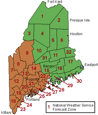
Northern and Eastern Zones (shown in green) are served by the National Weather Service Forecast Office in Caribou, Maine. Zones to the south and west (in brown) are served by the National Weather Service Forecast Office in Gray, Maine.
Additional Links
- Other notification services
-
MEMA no longer offers NWS weather alerts as part of our subscription services. MEMA offers emergency management news, emergency and safety information, upcoming events, training announcements and more through the Maine.gov subscription service. Learn more and sign up. We can recommend the following services for weather and other hazard notifications. Your preferred local news source may also provide online weather information or automated messaging.
American Red Cross Mobile Apps
These mobile apps are for emergencies and everyday use. The "Emergency" "all-inclusive" app lets you receive more than 35 different severe weather and emergency alerts, to help keep you and your loved ones safe. For Apple or Android.FEMA: Download Mobile App
From this page you can download FEMA's mobile app for Android, Apple or Blackberry mobile devices. Features timely weather alerts you can customize for your area, as well as preparedness and other information.FEMA: Wireless Emergency Alerts (WEA)
Wireless Emergency Alerts (WEA) are emergency messages sent by authorized government alerting authorities through your mobile carrier. Alerts include certain fast-breaking weather alerts (but not all alerts), Amber Alerts and national alerts.Maine Cooperative Snow Survey
The Maine Cooperative Snow Survey collects, interprets, and distributes information on the depth and water content of Maine's snowpack in the late Winter and early Spring. You can sign up to be notified whenever maps are posted or updated.NWS: iNWS (Interactive NWS)
A service of the National Weather Service, iNWS offers e-mail and text weather alerting customized by the user and is intended only for use by emergency managers, first responders, transportation and safety managers, public officials and the media.NWS: Listing of Email and SMS Weather Alert Services
National Weather Service-provided listing of services that provide weather alerts, either free or for a fee. NWS notes that inclusion in the listing does not constitute an endorsement of any particular service.NWS: NOAA Weather Radio
NOAA Weather Radio (NWR) is a nationwide network of radio stations broadcasting continuous weather information directly from the nearest NWS office. Weather Radios which pick up these broadcasts alert people while they're sleeping or climbing a mountain to possibly hazardous situations, and are especially valuable in Maine where so many people enjoy outdoor recreation.USGS: Earthquake Notification System
The Earthquake Notification Service (ENS) is a free service that sends you automated notification emails when earthquakes happen in your area. PLEASE NOTE: These are not earthquake warnings, as earthquakes cannot be predicted. They are notifications that an earthquake has occurred.USGS: WaterAlert
The U.S. Geological Survey WaterAlert service sends e-mail or text (SMS) messages when certain parameters, as measured by a USGS stream gage or other real-time data-collection station.Northeast River Forecast Center
USGS NWIS Real-Time Streamflow Data for Maine
National Weather Service Caribou Emergency Managers Self-Briefing Page
National Weather Service Gray Emergency Managers Self-Briefing Page
- Tides and Maritime Data