Home → Archives → 2009 Meetings → April 15, 2009
April 15, 2009 Meeting Minutes and Agenda
Time: 10:00 to 12:30
Place: Burton M. Cross Building, Conference Room 105.
AGENDA
1. Approval of the March 18th meeting minutes – Chair
2. CAT 3 Project – Nancy Armentrout & Project Team
• Finalization of Strategic Plan
• ILRIS Conceptual Framework
3. LIDAR Regional Project – Mike Smith
4. Subcommittee Reports
• Financial – Larry Harwood
• Policy & Marketing – Marilyn LutzSubmission of Data Sets
GeoPortal System Administrator Responsibility• Technical
Status of the GeoPortal – Mike Smith, Christopher Kroot
NEXT SCHEDULED MEETING: Wednesday May 20th , 2009, 10:00 a.m. – 12:30 p.m., Burton M. Cross Building, Conference Room 105.
Meeting Minutes
Present
Nancy Armentrout
Michael Smith
Marilyn Lutz
Greg Copeland
Gretchen Heldmann
Ken Murchison (by phone)
Paul Hoffman
William Hanson, Chair
Greg Davis (by phone)
Jon Giles
Aimee Dubois
Christopher Kroot
Staff
Larry Harwood
Visitors
Vinton Valentine, University Southern Maine (USM), Maine
GIS Users Group (MEGUG)
Rich Sutton, James W. Sewall Project Team (by phone)
Dan Walters, US Geological Survey (USGS)
The meeting was called to order at 10:02
1. Approval of the March 18th meeting minutes
The Chair entertained a motion to approve the minutes. Mike Smith
moved to approve the minutes as written. Gretchen Heldmann seconded.
The Board voted 9 in favor, none opposed, the Chair abstaining. The
motion carried.
2. CAT 3 Project
Strategic Plan
Nancy Armentrout opened discussion of the Strategic GIS Plan. This
had been presented in second draft form at the last meeting by Bruce
Oswald of the Sewall Project Team. There was agreement that this plan
had been well reviewed by now and that further input would be minimal.
Discussion focused on how to translate the Strategic Plan into an
action plan for the Board. The role of the Geolibrary “GIS Coordinator”
was reviewed; for the time being Mike Smith and Dan Walters may be
able to undertake some of these functions as part of their regular
jobs.
Nancy and Marilyn Lutz agreed to attempt a short version of the Strategic Plan for the next meeting. This would be something in the nature of a plan of action for the Board. Nancy asked if the Board was ready to approve the draft Strategic Plan as a deliverable and there were no objections.
Marilyn Lutz moved to accept the Strategic Plan now as a deliverable. Mike Smith seconded. The Board voted 10 in favor, none opposed the Chair abstaining. The motion carried.
ILRIS (Integrated Land Records Information System)
Nancy passed out and gave a short overview of the
ILRIS Conceptual Framework, v 4.0. Rich Sutton who drafting the ILRIS
plan documents as part of the James W. Sewall Project Team took over
and added more extensive commentary. This document is a high level
view and will be the most public part of the project. This will be
followed later by the more detailed Functional Specifications document.
There are 3 main components:
1. The creation of a statewide parcel data set.
2. The development of a perpetual maintenance system and network to keep the records current.
3. The addition of value by association with other related data sources.
The first component may seem somewhat unlikely at this point but federal funding may be available to do this. The existing Digital Parcel Standards would probably have to be modified to accommodate such a diverse input. The assessor’s database would also have to be made public with the Geolibrary parcel data ,which is not the case now, due to privacy concerns.
The second component is so important that it should be settled before actually creating the statewide data set. Maintenance has been neglected and there is a good deal of data out there that has never been updated, including the Geolibrary parcel data.
The third component would involve “collateral” databases managed by parcel. This category would especially include the county registries’ legal ownership data, deeds, surveys, easements, etc. This would be a joining of legal title and ownership information with municipal assessing information.
Q: There seems to be some confusion on the number
of attributes carried.
A: Yes, that is due to privacy concerns restricting
certain information. Also we did some pruning – more will be
coming in the Specifications.
Q: How do we account for vacant land, that is land
without buildings?
A: We have no answer for that right now. The assessor’s
databases doubtless carry that information.
Q: In other states, the privacy issue is handled
by not publishing names and telephone numbers. Could we do the same
thing?
A: Of course but there are many levels of “sanitizing”
the assessor’s data. Also there would be a difference between
what is made completely public and what is available to say state
and federal agencies. There are as many variations on this as there
are data sets but generally releasing private information “ruffles
feathers” even if it is a matter of public record.
Comment: Those of us in local government
are required to provide such information if asked. We have no choice
in the matter. Also there can always be a filing under Freedom of
Information Act, local state or federal.
Q: When can we expect to see the Functional Specifications?
A: Probably next week sometime.
Nancy concluded things by noting that the CAT 3 Project Team has been meeting about every 2 weeks and anyone wanting to join them would be welcome. If anyone has comments on what was covered today, please get them to Nancy or one of the Project Team by April 29th.
4. LiDAR Regional Project
Dan Walters reported that no award announcement has been seen yet
at USGS. The three eastern regions have about $5M between them and
the match will be 50/50. The proposed regional project has been mentioned
favorably. There is also the orthoimagery component to be considered.
Mike Smith reported that the other states in the proposed consortium are “on board” for the project. In addition certain state legislators are very interested in resurrecting the LiDAR bond issue. This bears watching and encouragement.
5. Subcommittee Reports
Financial
Larry Harwood presented the current financial sheet. There was only
one change to the financial sheet and that was the appropriation at
the last meeting of $20,000 towards the proposed regional LiDAR coastal
collection project. The remaining unencumbered funds total $42,370.50.
Expenditures being brought up. Mike Smith reviewed for the Board the
history of expenditures on the GeoPortal. His research is summarized
as follows:
$80K – Spent on the Ionic portal
$10K - to OIT (MEGIS) to install and configure the portal, $5300 of
which is unspent
$14K - to ESRI for customization, branding, training, $11,700 of which
is unspent and still on the contract
$8K - to ESRI for security fixes, never spent or put under contract
$22K - to USM for development of 'shapefile uploader'
$6K - to USM for metadata loading for certain organizations
$26K - to buy four servers, two at OIT used (now) for WMS hosting,
two at USM for the portal
Compared with the current financial sheet, it would appear that $4,000 of the ESRI contract is not accounted for. Larry will look into this and report at the next meeting.
Policy & Marketing
Submission of Data Sets
Marilyn Lutz presented the latest draft of the policy on “submission
of data sets to the GeoLibrary from sources outside state government”.
One added item (page 2 section 8) states that “The data provider
agrees not to upload copyrighted data they do not own. The GeoLibrary
Board reserves the right to remove any data at the request of the
owner if a copyright violation is reported.” This policy had
been reviewed several times before and discussion was limited.
Nancy Armentrout moved to accept the policy as written. Gretchen Heldmann seconded. The Board voted 11 in favor, none opposed, the Chair abstaining. The motion carried.
GeoPortal System Administrator Responsibility
Marilyn presented the latest draft of the policy on “GeoPortal
System Management”. There was considerable discussion. It was
suggested and informally accepted that a phrase about ‘ensuring
legal compliance’ should be added. Another suggestion was to
clarify that the Administrator will not be checking metadata exhaustively
nor fixing it.
It was asked if there existed any automated metadata/data checking software or applications. The opinion of the technicians was that there was not. There were additional questions on how upgrades to the GeoPortal software would be done and who would be involved in user support. Given the number of changes and questions, Marilyn agreed to redraft the policy and present it at the next meeting.
Technical
Status of GeoPortal
Mike Smith presented a number of documents intended to answer
some questions and concerns about the past progress and current status
of the GeoPortal. He reviewed the timeline and the appropriations
(as already noted above in the Financial section) from the Ionic effort
to the present day. He also reviewed the copies of the ESRI portal
consulting contract and the GeoPortal work agreement, with elaborative
documentation, between the Office of Information Technology (OIT)
and the University of Southern Maine (USM).
Mike also passed out the text of a lengthy motion he intended to make regarding the portal. He noted that the options available to the Board are limited. The ESRI portal kit version 9.2 is obsolete and eventually will not be supported. OIT cannot maintain the ESRI portal kit version 9.3 nor can they maintain GeoNetwork . USM cannot maintain ESRI 9.3 either. The choices were 1) go ahead with GeoNetwork hoisted by USM or 2) go back to the ESRI version 9.2 or 3) start all over again.
Q: Why can’t OIT support ESRI 9.3?
A: It requires a separate server and operating systems
that OIT does not support. They lack the personal to administer the
software and operating systems. Also with 9.3 we lost a lot of functionality
that we wanted and had in 9.2.
Q: Why not go back to 9.2?
A: We could but there will be problems down the road.
Most unsupported applications eventually simply fail to run on the
newer versions of operating software.
Q: Is the Board bound by the ESRI contract to pay
them anyway?
A: No. The contract was for time and materials so
it is moot now.
Q: When did the Board ever vote for or even approve
of using GeoNetwork for the portal?
A: A fair question. There was no vote. Based on the
minutes and notes it was left to the Technical Committee to select
a platform.
Q: Our big problem has been getting all the functionality
in the specifications list. How do we know GeoNetwork will provide
all that?
A: The technicians here and at USM are pretty confident
that it can. Most of the functions will be a result of customization,
not the simple framework you have seen so far. USM is not getting
paid until all the functions are there.
Q: How reliable is GeoNetwork? Is there the potential
of it just going away?
A: No, it has a very large support group spread over
many organizations. Also, being open source there are no version changes
as with vendor supported software.
Q: How long is the contract with USM?
A: Three years.
Q: Is the functionality to be done in phases?
A: It could be. We can look at that if you wish.
Q: The servers we bought are going to USM?
A: Yes but we can take them back at any time and they will not be
used for any other purpose; they are even in a separate place.
Mike Smith made the following motion, slightly amended from the written
handout:
1) to deallocate the remaining $11,700 from the $14,000 ESRI contract
for customization, configuration, and training for the ESRI GeoPortal
Toolkit 9.2 approved by the Board January 16 2008; and
2) to deallocate $5300 from the $10,000 OIT/MEGIS allocation for installation
and configuration of the ESRI GeoPortal Toolkit 9.2 approved by the
Board January 16 2008; and
3) to reallocate these unspent funds totaling $17,000 to the University
of Southern Maine Research Computing Group through an amendment to
the existing cooperative agreement for installation, customization,
hosting, and configuration of a GeoNetwork portal; and
4) to reallocate $1000 of the previously approved and unspent $8,000
allocation for ESRI GeoPortal Toolkit 9.2 security fixes to the University
of Southern Maine Research Computing Group for GeoNetwork portal security
configuration. By entering into this agreement, the University of
Southern Maine Research Computing Group will be bound by contract
to deliver the functionality specified in the Board's portal functionality
matrix, the cost not to exceed $18,000.
Greg Copeland seconded. By roll call the Board voted 9 in favor, none
opposed, the Chair abstaining. The motion carried.
There was no further business to discuss.
The meeting was adjourned at 12:04
Attachment A
Maine GeoLibrary Board
Integrated Land Records Information System
CONCEPTUAL FRAMEWORK: Working Draft (rev04)
April 15, 2009
JWS Team Contact: rs@restmap.net
Contents
1. INTRODUCTION & CONTEXT . . . . . . . . . . . . . . . . . .
. . . . . . . . . . . . . . . . . . . . . . . . . . . . . . . . .
. . . . . . . . . . . . . .7
DOCUMENT CONTEXT: . . . . . . . . . . . . . . . . . . . . . . . . . . . . . . . . . . . . . . . . . . . . . . . . . . . . . . . . . . . . . . . . . . . . .7
2. CONCEPTUAL CORE . . . . . . . . . . . . . . . . . . . . . . .
. . . . . . . . . . . . . . . . . . . . . . . . . . . . . . . . .
. . . . . . . . . . . . . . . . .8
3. STATEWIDE PARCELS COMPOSITE . . . . . . . . . . . . . . . . . .
. . . . . . . . . . . . . . . . . . . . . . . . . . . . . . . . .
. . . . . . . . .9
CREATION OF STATEWIDE UNIFORM PARCEL COVERAGE . . . . . . . . . . . . . . . . . . . . . . . . . . . . . . . . . . . . .9
4. PERPETUAL PARCELS MAINTENANCE . . . . . . . . . . . . . . . . . . . . . . . . . . . . . . . . . . . . . . . . . . . . . . . . . . . . . . . .13
PERPETUAL PARCEL MAINTENANCE MECHANISM IN ADVANCE OF STATEWIDE COVERAGE . . . . .13
5. INTEGRATING OTHER LAND RECORDS DATABASES . . . . . . . . . . . . . . . . . . . . . . . . . . . . . . . . . . . . . . . . . . . .14
INTRODUCTION & CONTEXT
The Maine Library of Geographic Information (“Geolibrary”) has been working with the Maine Office of Information Technology and the Maine Office of Geographic Information Systems (“MEGIS”) to help the State develop geographic information system (“GIS”) capabilities to promote efficient government administration and land use planning. Since April, 2008 the GeoLibrary has been gathering information to assist Maine in designing a GIS-based integrated land records information system (“ILRIS”) which would facilitate access to information about a particular parcel and adjoining lands. This effort has in part been funded by a $50,000 grant by The Federal Geographic Data Committee (“FGDC”) which promotes the coordinated development and dissemination of national geospatial data. The grant monies were obtained from the FGDC’s Fifty States Initiative and have been supplemented by contributions from the Geolibrary and MEGIS .
The Maine ILRIS would build upon and enhance the accessibility and utility of geographic information now maintained by data stewards at all levels of Maine government. Once implemented the ILRIS would allow all persons interested in the attributes of a particular parcel (among them, title examiners, planners, conservationists, and developers) to see a parcel on an aerial photograph (map quality orthoimagery is the desired standard), and readily access information about land cover, roads, protected lands, soils, wetlands, aquifers, geology and other pertinent geography. Under the envisioned ILRIS this information would also be linked with parcel title information maintained in the county deed registries. The current GeoLibrary project is a first step in determining how best to create these links.
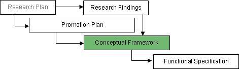
This document provides a Conceptual Framework for the proposed integrated land records system. Its purpose is to compile and formalize findings from extensive research into an overall set of goals that are realistically attainable and will promote the enhanced integration of Maine land records and improve access to property ownership and rights data in the state.
The Conceptual Framework for the Maine Integrated Land Records Information System has been developed as the result of input from multiple forums, meetings and discussions with geographic data users and potential stakeholders from all levels of government and the private sector both within and outside of Maine. It is a subcomponent of a structured set of deliverables, including Research, Promotion and ultimately a Functional Specification that will be used to assign roles and costs to facilitate attainment of project objectives.
I. Document Context:
Conceptual CORE
The Maine GeoLibrary seeks to develop a system of unified property records across the state. The basic principles of this initiative can be summarized in a three key assumptions about what a final system should include and about how these records should be aggregated and maintained. These include:
• Creation of a statewide parcel composite
• Development of a perpetual maintenance system and network to ensure these records are kept current
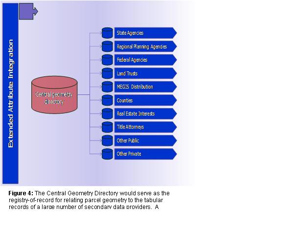
• Adding value to these data through technical association of individual records with other data sources through extended attributes sets.
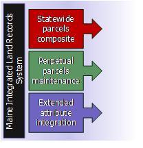
These three components would provide Maine with all of the critical data upon which to integrate and grow a coordinated land records system. They would also serve to build and maintain a cohesive network of data stewards compiling data at the most local levels and rolling it up to higher jurisdictions for use all the way to the federal level.
The parcels composite would include geometry and basic identifying descriptors of every individually documented property in the state. This would include digital property parcels in the form traditionally used for display and query in geographic information systems. The quality of the geometry and integrity of attached attribute data would be dictated by existing or extended Maine GeoLibrary parcel standard requirements.
Perpetual parcels maintenance would be instituted to ensure that these data remain accurate and current through time. Even if all of Maine’s 750,000+ property parcels could be delivered as an exhaustive composite tomorrow, without a working maintenance regime in place their accuracy would be compromised the following day. Rigorous data updating will ultimately require legislation to keep the many functional contributors actively participating and complying with the overall framework.
Widespread system utility and added value will be realized by integrating secondary data sources through shared attributes as well as geographic relationships. This is the functional goal which offers the greatest potential benefits to the greatest number of current and prospective GIS stakeholders. A mature integrated land records system will allow users to ask such questions as “where are all of the properties with shore frontage?” or “what is the current set of parcels in foreclosure?” or “show me all land in Maine’s Tree Growth program” and return accurate graphical as well as quantified tabular data with defensible answers.
The secondary sources, such as great ponds polygons, foreclosure filings or Tree Growth certifications, will only be accessible for map-based analysis once a parcels framework is available to integrate them with.
In pursuit of these core goals, a number of enabling tasks need to be undertaken to move the process forward incrementally. Anticipated tasks include:
• Refinement and enforcement of existing data standards
• Maintenance of an exhaustive inventory of data providers, including contacts, data characterization and distribution and access details.
• Coordination of participating stakeholders
• Pilot production of completed data
Statewide Parcels composite
II. Creation of Statewide Uniform Parcel Coverage
The central pillar of a Maine Integrated Land Records System will be an exhaustive boundary to boundary digital parcels layer for the state. To satisfy the needs of an effective ILRIS, this data layer must:
• Satisfy the basic needs of local assessing and planning entities; it must provide basic capabilities to address the most frequently posited queries; these are the 10% of questions asked 90% of the time
• Provide genuine utility for regional and state planning purposes
• Provide uniform attributes as well as geometry for every property in the state
• Conform with federal and state standards as a cadastral framework layer
Geometry Components
Allowable geometric tolerances of parcel features are well documented
in the existing Maine Parcel Standard as adopted in January, 2005.
These components include projection, line work, coincident features
and automation tolerances and address scale and accuracy considerations
appropriate for local as well as regional scale analysis.
If statewide data automation is to proceed smoothly, observance of
certain aspects of the geometry standard will be critical.
Management of edge-matching between municipalities is of particular
concern. Inconsistencies between adjoining towns’ parcels are
inevitable and in some cases quite pronounced. ILRIS must provide
tools to help adjust and reconcile these boundary inconsistencies
and facilitates efforts to resolve them. A provision exists in the
existing standard for coding such parcels as “in dispute.”
Because of existing and anticipated inconsistencies, all boundary
polygons should be coded and tracked with care in anticipation of
future initiatives geared specifically toward addressing this issue.
It is also advisable to establish grant conditions stipulating that parcels are digitized over the most accurate available base orthoimagery.
Attribute Components
In order for automation and maintenance to be practicable, the ILRIS
will need a basic, uniform attribute set. Again, the basis for this
will be the existing Parcel Standard requirements. Most of the vital
data components are already accounted for in this standard that will
facilitate optimal indexing and connection to associated data resources.
The Standard currently stipulates the following attribute fields (data attached directly to the geometric features) as the core requirement:
• STATE_ID: A unique, statewide identifier for each parcel. The township geocode constitutes the first five numbers of the identifier followed by a unique, sequential number generated by software for each parcel in the township. (numeric field)
• MAP_BK_LOT: A municipal designation field which carries the map, block and lot assigned to each parcel by the municipal assessor. This field is the link to the municipal databases. It may not be possible to make this link between the assessor’s database and the digital parcel map for every parcel or property record – a one to one relationship. This standard requires only an initial effort to make the linkage as complete as possible. (character field)
• PARENT: The map_bk_lot listing in the assessor’s database where information about a parcel may be found. Some Maine towns organize their tax assessing database so that only one bill is sent to each property owner. If the property owner holds several lots only one listing in the assessor’s database will be made to serve for all of them. In these cases one map-block-lot designation will be assigned to the combined listing. For the remaining lots, the parent field contains a pointer to the appropriate map-block-plot listing.
• PROP_LOC: The physical address of the property, if applicable. (character field)
A significant number of additional data fields are identified in the Standard as required (19). These are keyed to the primary fields through the STATE_ID and MAP_BK_LOT identifiers. These are fully referenced in the Functional Specification document.
A core attribute set is essential to ensure that parcel features can be keyed into the maximum number of tabular data sources based on shared attribute information. Of special note in this regard are the MAP_BK_LOT attributes, which key to municipal data, and the LS_BOOK and LS_PAGE fields, used to tie the data into County Registry data.
In addition to the fields listed above, the following would provide significant utility to a functional and forward looking integrated system:
• Maine ILRIS key: providing a unique identifier for any parcel in time; this would eliminate confusion associated with parcels renamed or renumbered by towns or forced into duplicate naming by parcels cuts and combines. Possible components of an ILRIS key have been identified to include:
o Server-generated identifier, assigned and validated against current existing list; this would need an operational owner, probably at the Office of Information Technology (OIT) but Maine Revenue Services (MRS) is a possibility as well.
o Municipally-generated identifier, assigned and validated according to rules established by state standard – area code and phone number --
o Assignment of this number should occur during the Real Estate Transfer Tax process;
Feature Storage and Distribution
In addition to the distributed repositories where parcels data is
stored and used to serve local needs, a standards-compliant extract
would be periodically inserted into a Central Parcels Directory. This
centralized repository would serve as the main point of standardization
as well as distribution of property parcel data and their key attribute
set.
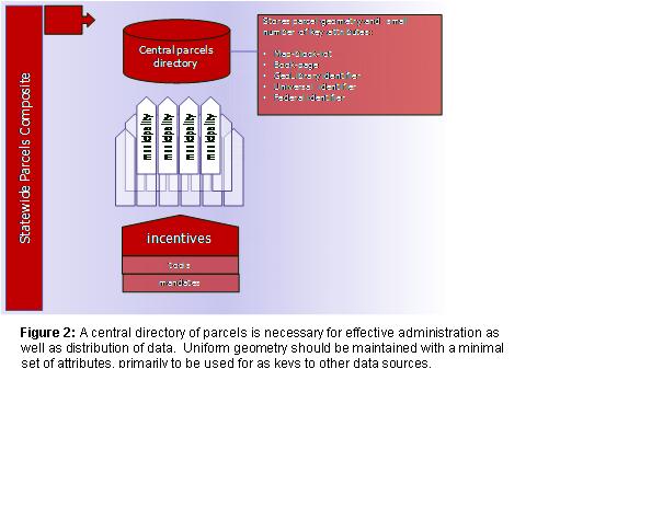
In an efficiently implemented system, a single repository could provide storage, editing and distribution capabilities for the entire state. There are no longer any meaningful technical impediments to such architectures, and substantial economies of scale could be realized by eliminating the need for a large quantity of expensive software (hundreds of licenses) along with the technical expertise necessary to maintain and operate it. The functional framework for this is currently coalescing in the state’s geodata portal.
Of course there are many benefits to keeping local, on-the-ground expertise and geographic data quality review and assurance (if not hands-on maintenance) in close contact, but the physical data does not need to be warehoused locally for this to operate most effectively. It is far more important that the data be carefully input and validated according to standards than that local expertise be maintained to edit and ensure the quality of geographic data in every town and city in Maine.
Strategies for Attaining Uniform Statewide Parcels
Accurate digital mapping of every parcel in the state presents considerable
technical and organizational challenges. Though the raw number of
overall parcels (<800,000) represents fewer than many individual
counties in the U.S., the organizational impediments posed by the
sheer number of maintaining entities are formidable: there are potentially
hundreds of potential points of failure in a working ILRIS.
Three possible paths have been identified as practical options for attaining a full statewide map down of digital parcel data. These include
• an incremental approach similar to what has been used in the previous rounds of parcel grants;
• a bundled automation approach, where groups of municipalities are tactically automated in unison, and
• a statewide blitz initiative, where the entire state is completed over an accelerated timeline. Descriptions of these follow.
Incremental development through individual municipal
grants
The most obvious approach to mapping
down property parcels for Maine is to use the tried and tested mechanisms
that have worked in previous rounds of state parcel grants. These
grants have resulted in compliance of more than 20% of Maine communities
with a standard, digital format.
However, unless the disbursements are increased significantly, the resources will be inadequate to the task. The parcel grant rounds were not funded or designed to develop new content, but to incentivize standardization and contribution of existing content.
Bundled automation of locally or demographically/developmentally
similar cohort towns
Opportunities exist to regionalize similar towns by
geography or characteristics and undertake collective mapping for
these municipalities in bulk. Ideally this would be an incentive-based
undertaking, where towns could be provided with standardized “80/20”
tools once their parcels were automated. Such tools would likely initially
serve assessing and planning needs.
Statewide blitz initiative
The quickest and most efficient approach
would be to gather up current assessing maps and assessing attributes
from all of the presently un-automated municipalities and exhaustively
digitize these using consistent quality controls. This would require
the largest mobilization of staff and resources, but economies of
scale would make it the most cost-effective approach overall.
It is unlikely that such an approach could be undertaken without some form of statewide enabling legislation.
Recent activities at the federal level are increasing the likelihood that resources may be made available to support this sort of aggressive approach as part of stimulus funding packages. In light of these developments it is important that implementation planning for this approach should be well considered should such federal funding be made available.
perpetual Parcels Maintenance
III. Perpetual Parcel Maintenance Mechanism in Advance of Statewide Coverage
Ongoing parcels editing and checking-in must be instituted to ensure all data in the repository remain accurate and current through time. The most persistent criticism of the 70+ towns’ data presently available via MEGIS download is that they are not up-to-date and there is no mechanism in place to make them so.
Many applications using digital property data rely on accurate representations of recent changes. In order to ensure that any comprehensive system provide maximum utility, it is therefore essential that the incremental changes occurring on the ground be reflected in the data repository as quickly and accurately as possible.
In the interest of achieving this state, there is a compelling case to made that day-forward digitizing and cataloging of these incremental changes to existing parcel standard municipalities should be instituted before statewide parcel data are pursued as an objective. Such a system would eliminate the possibility of data going stale following delivery of town-wide mapping.
A significant number of municipalities with digital parcels do not update these records actively (annually or less frequently) For this reason it would be favorable to enable perpetual maintenance capability without imposing the burden exclusively on the towns. Properly implementing such a maintenance scheme would provide a profound benefit to many geospatially underserved communities.
Perpetual maintenance could be facilitated in the following sequence:
1. Property owner subdivides a parcel
2. New deeds are generated
3. New ILRIS ID is created (using authentication server/service)
4. Deed language is conveyed to the municipality through RETT form transmittal
5. Municipality digitizes new parcel change according to deed language, survey or plan using local system
OR
5. Municipality digitizes new parcel change using central or regional system
OR
6. Municipality conveys manuscripts to contractor who performs changes and checks these into central system
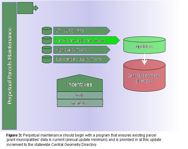
Strategic Principles for Perpetual Parcel Maintenance
• Proceed from existing parcel grant towns
• Build regime to ensure ongoing maintenance for every municipality meeting the standard
• Withhold additional grant-standard municipalities until ongoing maintenance strategy is secure
Integrating other Land Records Databases
Integrate Content from County Registries and other Sources
With the overall parcel geometry and maintenance in place, the benefits
of integrated land records can begin to accrue. At this stage the
parcel data are ready to be married with other data resources both
through tabular attributes (such as information stored about property
in Assessor’s databases) as well as through spatial relationships
(using proximity analysis tools).
Tabular content integration:
Municipalities: Assessing is primary source
Counties: Registry is the primary source. Interactive
data maintenance and access relationships must exist between current
GIS data resources (including municipal parcel records and MEGIS holdings)
and County deeds, surveys and other documents. Identified approaches
for developing these relationships and data conduits include:
• Initiate program to georeference scanned survey plans and distribute through web-based map services; this will serve the purpose of placing surveys accurately in real world geography
• Geocode (add x,y pair) to metadata associated with individual deeds and develop application programming interface to access by geographic queries
• Institute a uniform property identifier (ILRIS ID)
Coda
Integrated Land Records, marrying digital tax parcel maps with information from municipalities, counties and state agencies, are an indispensable tool for modern governance.
Over the past twenty-five years geographic information systems (GIS) have been used to enable these tools, primarily at the local level in larger cities. And the Maine GeoLibrary has taken impressive initial strides toward integrating these systems more cohesively through targeted grants and planning efforts over the past ten years.
But the overall coverage in the state remains spotty and inconsistent. Maintenance of the data that do exist is not uniform or dependable, and hundreds of towns around the state have no access to the technology and its benefits.
Digital parcel mapping is the only practical means to exhaustively inventory property records, locally, regionally or statewide. The intelligent map that this technology provides may be queried, symbolized, shared and refined to provide a common operating picture for all potential users of property records data.
And there are many. Not just property assessors or appraisers, but analysts, regulators and enforcement officers in environmental agencies, transportation, health and economic development.
What properties have shorefront access? Where is the land in the Tree Growth program? Where is the real estate in foreclosure or in pre-foreclosure status? How many private parcels abut or are in visual range of wind farms? How many individual properties lie over a particular wetland or deer yard? Where are all of the properties that have sold or split in the past year?
All of these questions can be answered with simple queries against a property database. None of these questions can be answered here now.
In Maine, where land plays such a vital role in local livelihoods
and sense of place, the tools should be available to address and answer
these and countless other questions vital to the state and local interests.