DACF Home → Bureaus & Programs → Maine Natural Areas Program → Ecological Reserves → Big Spencer Mountain
(Printer Friendly Version-31 KB pdf) (Download a free copy of Adobe Acrobat Reader)
Big Spencer Mountain
TX R14 WELS, T2 R13 WELS
Vital Statistics
- Size: 4,244 acres
- Regulated: N/A
- Non-Regulated: N/A
- Upland: 4,203 acres
- Forested Wetland (NWI): 15 acres
- Non-Forested Wetland: 26 acres
- Open Water: 0 acres
- Roads: trails - 3 miles
- Biophysical Region: Central Maine Mountains
- BPL Region: North
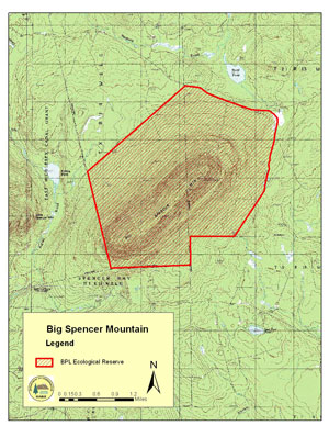
(Download a Printer Friendly Version-588 KB pdf-of this map.)
Exemplary Natural Communities
| Scientific Name | Common Name | State Rank | Global Rank |
|---|---|---|---|
| Beech - Birch - Maple Forest | Northern Hardwoods Forest | S4 | G3G5 |
| Fir - Heart-leaved Birch Subalpine Forest | Subalpine Fir Forest | S3 | GNR |
Rare Plants
There are no documented occurrences of rare plants within this Ecoreserve.
Rare Animals
There are no documented occurrences of rare animals within this Ecoreserve. For more information on rare animals in Maine, visit the Maine Department of Inland Fisheries and Wildlife.
Description
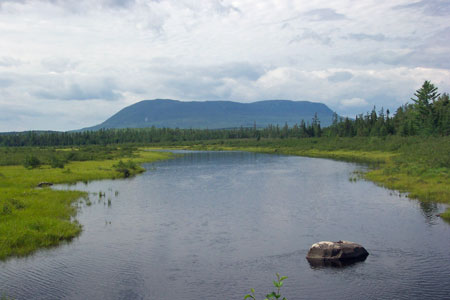
Formed from intrusive, volcanic rocks that originated roughly 400 million years ago, Big Spencer Mountain dominates the landscape northeast of Moosehead Lake. The plant communities of Big Spencer together form a good representation of montane forests progressing up an elevational gradient.
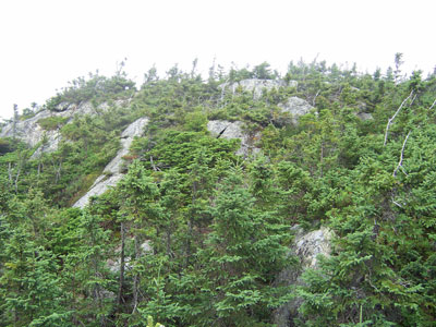
The lengthy summit ridge is a mosaic of Fir-heart-leaved Birch Subalpine Forest and krummholz. Vegetation is variably stunted (up to ten feet tall) and extremely dense balsam fir and black spruce, in most areas underlain by a thick carpet of mosses. This area of stunted forest extends for nearly 200 acres along the spine of the mountain.
From 3000 feet down to roughly 2200 feet, a Fir-heart-leaved Birch Subalpine Forest predominates, with little to no evidence of past harvesting but frequent evidence of natural disturbance -- from both past insect damage and wind/ice damage. The low basal area, tree height, and volume in this type, coupled with the steep and rocky slopes, would render this type inoperable from a timber standpoint. At the base of the steep northwest slope, a narrow (150' wide) band of heart-leaved birch, visible on the air photos, separates the subalpine forest from the lower elevation hardwood forest.
The mountain drops off steeply to the southeast, with numerous sparsely vegetated cliffs --- the largest roughly 150 feet tall. Vegetation on these acidic cliffs consists of narrow benches and crevices supporting three-leaved cinquefoil (Sibbaldiopsis tridentata), whorled aster (Oclemena acuminata), meadowsweet (Spiraea alba), lichens, and broom-mosses.
Middle and lower slopes, both on the northwest and southeast sides, are mixed-wood and hardwood dominated, with some areas showing signs of past harvesting (i.e., within the past two to three decades). Heavier past harvest levels are evident within about 1/2 mile of the road network. On the north side of the mountain, past harvest signs are minimal above 1700 feet, and on the east side harvest signs are minimal above 1900 feet. Basal area in these mid-elevation intact stands is roughly 110 sq. feet/acre. One cedar tree was measured to be 36 inches in diameter, and a few spruce trees on these lower and intermediate slopes were aged to be over 200 years old.
The most botanically interesting features of these lower hardwood and mixed wood slopes are seasonal drainages -- one following the T2 R13/TX R14 town boundary on the north side of the mountain and several others on the lower western slopes. These seasonal drainages support several uncommon rich woods species, such as grape fern (Botrychium virginianum), millet grass (Milium effusum), Braun's holly fern (Polystichum braunii), and mountain sweet cicely (Osmorhiza berteroi).
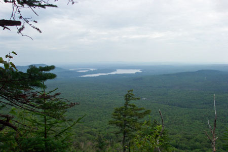
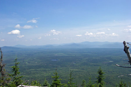
A steep, eroding trail leads up the east slope of the mountain, reaching an old warden's cabin at about 1900 feet in elevation. The trail to this point has been used y snowmobilers, and the cabin has been used as a winter warming hut. The state is exploring other alternate snowmobile trail option in the region so that this trail may be closed to motorized recreation in the future. The trail terminates at the mountain's east summit, which is occupied by an unattended fire tower, two large banks of solar panels, a small communications building, and a wood platform. The summit affords panoramic views in all directions, including Mt. Katahdin and many of the region's larger lakes.