DACF Home → Bureaus & Programs → Municipal Planning Assistance Program → Service Centers
Maine's Service Centers
Where is your nearest hospital located? Where do you work? Where do you bring the kids to buy school clothes, visit a museum or swim in an indoor pool? Whether the answer is Waterville, Damariscotta, Dover-Foxcroft, Portland or Presque Isle, the communities where we work, shop, obtain medical care or enjoy a cultural experience are what the Legislature has termed "service centers" or "regional service centers."
Maine is a rural state, but it depends on these urban places' vitality for its economic and social well-being. Accordingly, Maine's Growth Management Law (5 MRSA, Section 3234) requires that service centers receive priority consideration for certain state capital investments. DACF's Municipal Planning Assistance Program is responsible for periodically updating the below list of service centers.
History and Service Center Identification
In Maine, as elsewhere in the US, the late 1960s and 1970s was a period of rapid suburbanization. By the mid-1990s, there was evidence that 30 years of disbursed growth had significant cost and policy implications for the State. It also appeared that fiscal and policy decisions of state government often drove sprawl. For instance, state school siting criteria forced the abandonment of more compact in-town sites and the construction of new schools on larger, more-distant rural parcels.
In 1997, State Planning Office research into the fiscal and other costs associated with the shifting development pattern was summarized in The Cost of Sprawl. That publication pointed to the decline of our service centers as one of the most pervasive and costly effects of sprawl. It also held that revitalizing our service centers is the key to countering those effects.
In 1998, the Maine Legislature's Task Force on Regional Service Centers examined characteristics and problems unique to service centers and, in its report, Reviving Service Centers, recommended strategies for strengthening them. The Legislature enacted legislation requiring a formal process for the identification of those communities. The Methodology for Identifying Regional Service Centers (Amended Chapter 220) was adopted in 2002. The 2023 update to the list of Service Centers followed the method, and the 2023 Service Center Report to the Legislature recommends updates to this methodology.
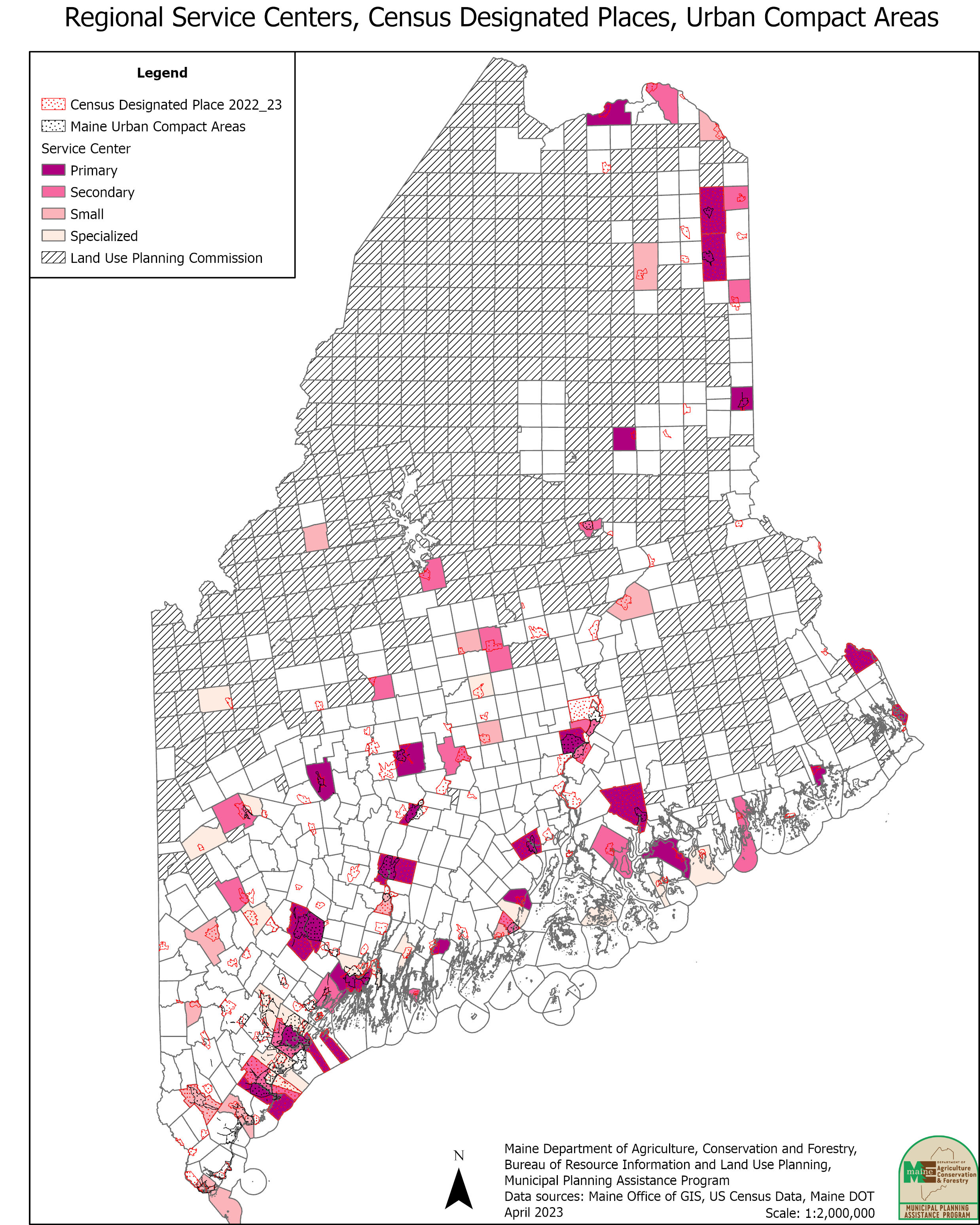
Service Centers Calculated 2023 |
|||
|---|---|---|---|
| Primary: | Secondary: | Small: | Specialized: |
| Auburn Augusta Bangor Bar Harbor Belfast Biddeford Brunswick Calais Camden Caribou Damariscotta Eastport Ellsworth Farmington Fort Kent Hallowell, new 2023 Houlton Lewiston Machias Patten, new 2023 Portland Presque Isle Skowhegan Waterville | Bingham Blue Hill Boothbay Harbor Brewer Dover-Foxcroft Freeport Greenville Limestone Madawaska Mars Hill Milbridge Millinocket Norway Orono Pittsfield Rockland Rumford Saco South Portland Westbrook | Ashland Bridgton Cornish Gardiner Guilford Jackman Kennebunk Kittery Lincoln Newport Sanford Thomaston Van Buren | Bath Bethel Dexter Falmouth Mexico Old Orchard Beach Oxford Rangeley Rockport Scarborough Southwest Harbor Stonington Topsham Windham Winter Harbor Wiscasset |
| Urban Compact Areas Designated as Regional Service Centers: | |||
|
|||
| Census Designated Places Designated as Regional Service Centers: | |||
|
|||
| Primary: had a score of at least 1.0 on all four criteria measured. Secondary: had a score of 1.0 on three of the four criteria and scored above 0.5 on the fourth criteria. Small: scored above 1.0 on two of the four criteria and above 0.5 on the other two criteria. Specialized: fall into an “all other” category and represent Secondary, Small, Specialized. Urban Compact Areas: means that portion of a municipality that the Maine Department of Transportation has identified as a compact area of an urban compact municipality pursuant to 23 M.R.S.A sec754 Census Designated Places: means a portion of a municipality that (1) the United States Bureau of the Census defined as a census designated place based on the most recent decennial census; (2) has a densely settled population center with a definite residential core with a density of 1,000 or more persons per square mile; and (3) includes commercial, industrial or other urban land uses. |
|||