DACF Home → Bureaus & Programs → Maine Geological Survey → Maps, Publications and Online Data → Using Geologic Maps → 1:250,000-scale Surficial Geology Maps
Surficial Geology 1:250,000-scale Maps Description
What are surficial deposits?
Sand, gravel, clay, and other unconsolidated materials that overlie bedrock are known as surficial deposits. They cover most of Maine's land surface and include sediments deposited by water, wind, and glacial ice. Glacial deposits are by far the most abundant surficial materials in Maine.
1:250,000-scale Surficial Geology Maps
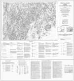
This series of black-and-white maps contains the information used to compile the 1985 Surficial Geologic Map of Maine. In addition to a description of surficial materials, the maps include the location of deltas, sites of special interest, radiocarbon-dated sites, and sources of geologic information.
Uses of surficial geology information
Identification of surficial materials is critical for making a number of land use decisions, including determining the suitability of an area for development, planning major construction projects, or looking for sources of ground water. Surficial geologic maps also provide information on the location and extent of sand and gravel deposits. Large scale (1:24,000 or larger) maps are most useful for investigations of particular sites.
How to obtain or view these maps
Use the Maps and Publications Search to identify printed and online publications available from the Maine Geological Survey. You can search for maps and publications by geographic area or subject. Search results are linked to online publications. To order printed materials see the ordering instructions.
Use our online surficial geology map list to link directly to the quadrangle of your choice.
Last updated on July 15, 2015