DACF Home → Bureaus & Programs → Maine Geological Survey → Maps, Publications and Online Data → Using Geologic Maps → Coastal Sand Dune Geology Maps
Coastal Sand Dune Geology 1:4,800-scale Maps Description
What is a sand dune?
Sand dune systems are sand and gravel deposits within a marine beach system, including, but not limited to beach berms, frontal dunes, dune ridges, back dunes, and other sand and gravel areas deposited by wave or wind action. Coastal sand dunes may extend into the coastal wetlands. The dune system includes areas which have been artificially covered by structures, lawns, roads, and fill.
Coastal Sand Dune Geology Maps
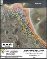
These color maps provide detailed information about Maine's largest beaches and dune systems. The photos show frontal dunes, back dunes, and erosion hazard areas conforming to the Department of Environmental Protection's 2006 Coastal Sand Dune Rules. For more information, read the photo explanation (pdf) or link to our tips for reading coastal sand dune geology maps.
Sand Dune Maps
The 2001 Beach and Dune Geology Aerial Photographs and the 2011 Coastal Sand Dune Geology Maps have been superseded by newer, more detailed 2023 Coastal Sand Dune Geology Maps.
Uses of sand dune information
Permits are usually required for building projects located in Maine's coastal sand dune system. Such projects are described in the Coastal Sand Dune Rules of the Maine Department of Environmental Protection. The rules are based on the location of the project within the sand dune system. These beach and dune geology maps delineate dunes that make up the coastal sand dune system. The boundaries shown on the photos provide guidance for interpreting the geology of the dune system with respect to the Coastal Sand Dune Rules. The location of the boundaries of the frontal dune (D1), the back dune (D2), and the Erosion Hazard Area (EHA) are especially important in the permit process.
How to obtain or view these maps
Use the Maps and Publications Search to identify printed and online publications available from the Maine Geological Survey. You can search for maps and publications by geographic area or subject. Search results are linked to online publications. To order printed materials see the ordering instructions.
Use our online coastal sand dune geology map list to link directly to the photo of your choice.
Last updated on June 30, 2023