DACF Home → Bureaus & Programs → Maine Geological Survey → Maps, Publications and Online Data → Using Geologic Maps → Bedrock Geology Maps
Bedrock Geology Maps
What is bedrock?
The literal foundation of Maine is its bedrock. Bedrock is the solid, intact part of the earth's crust, the outer layer 20 to 25 miles thick that rests on the earth's mantle. In most places in Maine, the bedrock is concealed by a thin veneer of unconsolidated sediment (mainly deposited by Ice Age glaciers), soil, and vegetation. Whereas parts of southern Arizona or Louisiana may have thousands of feet of unconsolidated surficial material overlying bedrock, the "depth to bedrock" in Maine is generally only a few tens of feet and rarely over a hundred. Some of the most beautiful scenery in Maine is where the rugged bedrock is exposed to view - along the "rock-bound" coast at Portland Head Light or Pemaquid, or on bare mountain tops such as Mount Katahdin, Cadillac Mountain, the Camden Hills, or Mount Kineo. In fact, the general distribution and shape of Maine's mountainous and lowland terrains is controlled by the way different kinds of bedrock have been eroded differently through geologic time.
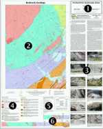
Bedrock geology maps
A bedrock map is the geologist's prediction of what kind of rock will be encountered below the surface based on observed surface exposures.
Bedrock maps show what kinds of rock are beneath a given area, and how the different rocks are related to each other. By looking at places where the bedrock is exposed at the surface, geologists identify areas where the rocks are similar, and infer contacts between rocks that are different. In this way, bedrock geology maps are generalized from many individual points of observation. Due to the uneven distribution of natural outcrops in Maine, the accuracy of bedrock maps ranges from very good in some places to quite poor in others.
Many bedrock characteristics may be displayed on a geologic map. In addition to the fundamental information about what kinds of rock are present, features such as orientation of layers, metamorphic or igneous fabrics, mineral or fossil occurrences, and faults or fractures may be shown. Because each place has its own unique set of bedrock characteristics, each bedrock map is designed to best describe the features recorded by the geologist in that map area.
Uses of bedrock geologic information
The information provided on bedrock geologic maps may be used in many ways. Any significant subsurface activity, such as excavating for building foundations, installing bridge footings or power poles, quarrying gravel, or drilling water wells may encounter bedrock. A bedrock map is the geologist's prediction of what kind of rock will be encountered below the surface based on observed surface exposures. Quarries, whether for dimension stone such as granite or for crushed rock aggregate with particular strength characteristics, are best sited in appropriate rock types. Exploration geologists or mineral collectors looking for metal ores, industrial minerals, or gemstones may be interested in specific rock types likely to contain the minerals of interest. Engineers planning roads or transmission line routes may use bedrock maps in conjunction with surficial geologic maps to see where valleys, ridges, and hills are controlled structurally by shallow bedrock rather than by unconsolidated deposits. Soil chemistry, important to agriculture and natural plant ecology, is related to bedrock composition because rock weathering contributes to soil formation. Water from wells drilled into bedrock may contain dissolved iron, manganese, calcium, or other undesirable constituents that occur naturally in higher concentrations in some rocks than in others. Ground-water flow in bedrock, relevant to water supply and contaminant transport issues, is controlled in a complicated way by the rock structure, including lithologic layering, metamorphic foliation, folds, dikes, and fractures, any of which may be indicated by symbols on the map. The distribution of rock units, their geometric relationships on the map, and the map explanation together indicate the origin of each unit and the geologic history that occurred.
Regional scale maps (1:100,000 or 1:500,000) provide a regional context that allows information from one area to be applied to another if the bedrock is sufficiently similar.
How to obtain or view these maps
Use the Maps and Publications Search to identify printed and online publications available from the Maine Geological Survey. You can search for maps and publications by geographic area or subject. Search results are linked to online publications. To order printed materials see the ordering instructions.
Use our online bedrock map list to link directly to the available maps.
Last updated on July 15, 2015